
Page 89 - eProceeding - IRSTC & RESPEX 2017
P. 89
Che Ku Ahmad Fuad bin Che Ku Abdullah / JOJAPS – JOURNAL ONLINE JARINGAN COT POLIPD
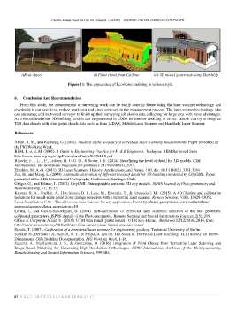
i)Real object ii) Point cloud from Cyclone iii) 3D model generated using SketchUp
Figure 11: The appearance of Eco-home building in various style.
6. Conclusion And Recommendation
From this study, the measurement or surveying work can be easily done in future using the laser scanner technology and
absolutely it can save time, reduce work cost and gives accuracy in the measurement process. The laser scanner technology also
can encourage and motivated surveyor to finish up their surveying job also in data collecting for large area with these advantages.
As a recommendation, 3D building models can be generated in LOD4 for interior detailing in future. Also it can try to integrate
TLS data clouds with other point clouds data such as from LiDAR, Mobile Laser Scanner and Handheld Laser Scanner.
References
Alkan, R. M., and Karsidag, G. (2012). Analysis of the accuracy of terrestrial laser scanning measurements. Paper presented at
the FIG Working Week.
BEM, B. o. E. M. (2005). A Guide to Engineering Practice for M & E Engineers. Malaysia: BEM Retrieved from
http://www.bem.org.my/v3/pdf/circulars/Guide%20M&E.pdf.
Biljecki, F. I. L. I. P., Ledoux, H. U. G. O., & Stoter, J. E. (2014). Redefining the level of detail for 3D models. GIM
International: the worldwide magazine for geomatics 28 (November), 2014.
Ebrahim, M. A.-B. (2011). 3D Laser Scanners: History, Applications, and Future. 100. doi: 10.13140/2.1.3331.3284
Fan, H., and Meng, L. (2009). Automatic derivation of different levels of detail for 3D buildings modelled by CityGML. Paper
presented at the 24th International Cartography Conference, Santiago, Chile.
Gröger, G., and Plümer, L. (2012). CityGML–Interoperable semantic 3D city models. ISPRS Journal of Photogrammetry and
Remote Sensing, 71, 12-33.
Kromer, R. A., Abellán, A., Hutchinson, D. J., Lato, M., Edwards, T., & Jaboyedoff, M. (2015). A 4D filtering and calibration
technique for small-scale point cloud change detection with a terrestrial laser scanner. Remote Sensing, 7(10), 13029-13052.
Leica ScanStation C10 – The all-in-one laser scanner for any application, from http://leica-geosystems.com/products/laser-
scanners/scanners/leica-scanstation-c10
Lerma, J., and García-San-Miguel, D. (2014). Self-calibration of terrestrial laser scanners: selection of the best geometric
additional parameters. ISPRS Annals of the Photogrammetry, Remote Sensing and Spatial Information Sciences, 2(5), 219.
Office of Corporate Affair, U. (2016). UTM bina rumah pintar lestari - UTM Eco-Home. Retrieved 12/12/2016, 2016, from
http://www.news.utm.my/2016/12/utm-bina-rumah-pintar-lestari-utm-eco-home/
Schulz, T. (2007). Calibration of a terrestrial laser scanner for engineering geodesy. Technical University of Berlin.
Sadikin, H., Hernandi, A., Saptari, A. Y., & Puspa, A. (2015). The Study of Terrestrial Laser Scanning (TLS) Survey for Three–
Dimensional (3D) Building Documentation. FIG Working Week, 1-18.
Salacha, A., Markiewicza, J. S., & Zawieskaa, D. (2016). Integration of Point Clouds from Terrestrial Laser Scanning and
Image-Based Matching for Generating High-Resolution Orthoimages. ISPRS-International Archives of the Photogrammetry,
Remote Sensing and Spatial Information Sciences, 399-404.
87 | V O L 7 - I R S T C 2 0 1 7 & R E S P E X 2 0 1 7