
Page 16 - NYS_ESS_07-2025
P. 16
Advanced Scanning Technology Solves
Advanced Scanning Technology Solves
Underground Puzzle
Underground Puzzle
By Linda Duffy
When faced with mapping over 10,000 linear feet of utility tunnels, with
some portions located five stories underground, Colliers Engineering &
Design (CED) customized their approach by applying advanced 3D
scanning technology. Rather than relying on traditional surveying methods
that would have required months of manual measurements, the team used
a variety of scanning systems, including the Trimble X7, NavVis VLX and
Leica RTC 360.
Managing Aging Utilities
A network of 100-year-old underground passageways containing heating
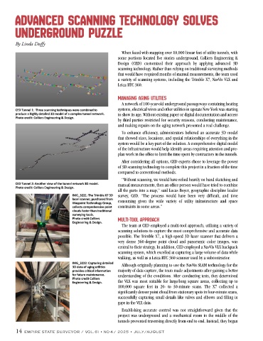
CED Tunnel 1: Three scanning techniques were combined to systems, electrical wires and other utilities in upstate New York was starting
produce a highly detailed 3D model of a complex tunnel network. to show its age. Without existing paper or digital documentation and access
Photo credit: Colliers Engineering & Design.
by third parties restricted for security reasons, conducting maintenance,
and making repairs on the aging network presented a real challenge.
To enhance efficiency, administrators believed an accurate 3D model
that showed sizes, locations, and spatial relationships of everything in the
system would be a key part of the solution. A comprehensive digital model
of the infrastructure would help identify areas requiring attention and pre-
plan work in the office to limit the time spent by contractors in the tunnels.
After considering all options, CED experts chose to leverage the power
of 3D scanning technology to complete this project in a fraction of the time
compared to conventional methods.
“Without scanning, we would have relied heavily on hand sketching and
CED Tunnel 2: Another view of the tunnel network 3D model. manual measurements, then an office person would have tried to combine
Photo credit: Colliers Engineering & Design.
all the parts into a map,” said Lucas Boyer, geographic discipline leader
IMG_3221: The Trimble X7 3D survey, CED. “The process would have been very difficult, and time
laser scanner, purchased from
Waypoint Technology Group, consuming given the wide variety of utility infrastructure and space
collects comprehensive point constraints in some areas.”
clouds faster than traditional
surveying tools.
Photo credit Colliers Multi-tool Approach
Engineering & Design.
The team at CED employed a multi-tool approach, utilizing a variety of
scanning solutions to capture the most comprehensive and accurate data
possible. The Trimble X7, a high-speed 3D laser scanner that delivers a
very dense 360-degree point cloud and panoramic color images, was
central to their strategy. In addition, CED employed a NavVis VLX backpack
scanning system, which excelled at capturing a large volume of data while
walking, as well as a Leica RTC 360 scanner used by a subcontractor.
IMG_3222: Capturing detailed Although originally planning to use the NavVis SLAM technology for the
3D data of aging utilities
provides critical information majority of data capture, the team made adjustments after gaining a better
for future maintenance. understanding of the conditions. After conducting tests, they determined
Photo credit Colliers
Engineering & Design. the VLX was most suitable for large/long square areas, collecting up to
100,000 square feet in 20- to 30-minute scans. The X7 collected a
significantly denser point cloud from stationary spots in four-minute scans,
successfully capturing small details like valves and elbows and filling in
gaps in the VLX data.
Establishing accurate control was not straightforward given that the
project was underground and a mechanical room in the middle of the
tunnels prevented traversing directly from end to end. Instead, they began
14 EMPIRE STATE SURVEYOR / VOL. 61 • NO 4 / 2025 • JULY/AUGUST