
Page 456 - The Arabian Gulf States_Neat
P. 456
388 THE LEGAL STATUS OF THE ARABIAN GULF STATES
purpose of Ihe exploration for and exploitation of the natural
that area. resources of
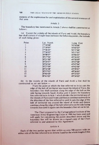
Article 3
The boundary line mentioned in Article 2 above shall be constructed as
follows:
(a) Except the vicinity of the islands of Farsi and Arabi, the boundary
line shall consist of straight lines between the following points, the latitude
of each being given:
Point Lat. North. Long. East
1 27°10'00" 50°54'00"
2 27°18'05" 50°45'05"
3 27°26'05" 50°37'00"
4 27°56'05" 50°I7'05"
5 28°08'05" 50°06'05"
6 28°17'06" 49°56'02"
7 28°2rOO" 49°50'09"
8 28°24'07" 49°47'08"
9 28°24'04" 49°47'04"
10 28°27'09" 49°42'00"
28°34'08" 49°39'07"
12 28°37'02" 49°36'05"
13 28°40'09" 49°33'05"
14 28°41 '03" 49°34'03"
(b) In the vicinity of the islands of Farsi and Arabi a line shall be
constructed as set out below:—
From the point at which the line referred to in (a) cuts the
edge of the belt of territorial sea round the island of Farsi, the
boundary line shall continue along the edge of the belt on the
side facing towards Saudi Arabia until it meets the boundary
line referred to in Article I which divides the territorial seas of
the islands of Farsi and Arabi and thence continue eastwards in
the direction of the line referred to until it cuts the edge of the
belt of territorial sea around the island of Arabi and thence
continue along the edge of the belt referred to on the side facing
towards Iran until it again cuts the boundary line set out in (a).
The Chart prepared by the Cartographical Institute of the
American Army Engineering Corps in 1966 has been used and
will apply for calculating the points described above and the
boundary line will be drawn on a signed copy of the Chart
referred to and annexed to this Agreement.
Article 4
Each of the two parties agrees that within an area 500 metres wide^ on
either side of the line referred to in Article 3 and for the whole length ot tnis