
Page 458 - The Arabian Gulf States_Neat
P. 458
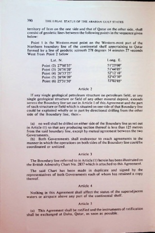
390       THE LEGAL STATUS OF THE ARABIAN GULF STATES

               territory of Iran on the one side and that of Qatar on the other side, shall
               consist of geodetic lines between the following points in the sequence given
               below:
                 Point 1 is the Western-most point on the Western-most part of the
               Northern boundary line of the continental shelf appertaining to Qatar
               formed by a line of geodetic azimuth 278 degrees 14 minutes 27 seconds
               West from Point 2 below
                            Lat. N.                       Long. E.
                       Point (2) 27°00'35"                51°23'00"
                       Point (3) 26°56'20"                51°44'05"
                       Point (4) 26°33'25"                52° 12'10"
                       Point (5) 26°06'20"                52°42'30"
                       Point (6) 25°31'50"                53°02'05"

                                          Article 2
                 If any single geological petroleum structure on petroleum field, or any
               single geological structure or field of any other mineral deposit, extends
               across the Boundary line set out in Article 1 of this Agreement and the part
               of such structure or field which is situated on one side of that Boundary line
               could be exploited wholly or in part by directional drilling from the other
               side of the Boundary line, then:-

                 (a)  no well shall be drilled on either side of the Boundary line as set out
               in Article (1) so that any producing section thereof is less than 125 metres
               from the said boundary line, except by mutual agreement between the two
               Governments,
                 (b)  Both Governments shall endeavour to reach agreements to the
               manner in which the operations on both sides of the Boundary line could be
               coordinated or unitized.
                                          Article 3
                 The Boundary line referred to in Article (1) herein has been illustrated on
               the British Admiralty Chart No. 2837 which is attached to this Agreement.
                 The said Chart has been made in duplicate and signed by the
               representatives of both Governments each of whom has retained a copy
               thereof.

                                          Article 4
                 Nothing in this Agreement shall affect the status of the superadjacent
               waters or  airspace above any part of the continental shelf.
                                          Article 5
                 (a) This Agreement shall be ratified and the instruments of ratification
               shall be exchanged at Doha, Qatar, as soon as possible.