
Page 26 - SuDS Design & Evaluation Guide-Newham V4 Spreads
P. 26
6.0 during rainstorms.
Local SuDS requirements for
Local SuDS requirements
Newham has a high rate of new development
The London Borough of Newham
and SuDS are a requirement for all major
development. Many SuDS scheme have now
been implemented through the planning
In April 2019, Newham Council declared a climate emergency and committed to
process. In addition, Newham, through the
becoming carbon neutral by 2030 and carbon net zero by 2050’ LLFA’s functions, implements its own SuDS
Newham Climate Now scheme on public highways and other council Local SuDS requirements
Landscape Character owned land (See Fig.2)
The London Borough of Newham (LBN),
located on the north side of the River
Thames, encompasses an area of 3,600 ha
bound on three sides by tidal watercourses:
the River Lee to the west, the River Roding to Fig.3 Newham Bedrock Geology
the east and the River Thames to the south.
In the south of the borough, the Royal Docks,
collectively form the largest enclosed docks
in the world and a major feature of the
borough. The Thames Barrier protects
Newham from flooding by tidal surges on
both the Thames and the Lea. The Barking Fig.2 One of the 11 SuDS beds delivered by
Newham across the Stratford Gyratory
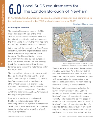
21 Creek Barrier protects the River Roding. combined (Brown); Stormwater (Blue) 22
Fig.1 Newham Sewer Infrastructure:
Entrance locks control the water levels within Local Geology
the Royal Docks. There are some notable areas of open space Newham’s bedrock geology is mostly
including West Ham Park, Beckton District
The borough’s terrain generally slopes south Park and Thames Barrier Park. However the represented by London Clay (Thames Group)
towards the River Thames and the Royal majority of the borough is densely developed and Lambeth Group layers denoting spatially
Docks. The borough is dissected by artificial with a predominantly impermeable urban variable permeability (very low to moderate).
landforms corresponding to railways and fabric, creating conditions for flash flooding In the southern aspect of the borough are
other infrastructures (e.g. the Greenway - and water ponding in low lying areas. notable two contiguous formations of Thanet
Northern Outfall Sewer). These features can Sand and White Chalk associated with high Fig.4 Newham Superficial Deposits Geology
act as barriers to, or conveyors of, overland Newham has been assessed as having the to very high permeability. (Fig.3) There are extensive areas of made ground
runoff and determine conditions for localised lowest sewer capacity of all 33 London Superficial deposits are largely dominated by found across the borough as indicated in Fig.
flooding during rainstorms. boroughs (Thames Water’s assessment 2018). river terrace deposits (characteristically free
Newham’s sewer infrastructure is nearing 5. Significant land contamination issues
Newham’s urban fabric is made up of capacity and projected to be over capacity draining) found in the central- northern originating from historical industrial use, can
traditional Victorian terraces with an within the next 20-30 years. More than half of aspect of the borough. Alluvium (with a more be found across the borough. The water
increasing amount of high density mixed-use Newham’s sewer infrastructure consists of a variable degree of permeability: low to table denotes a high degree of variability
development, replacing disused or underused historical combined sewer system providing medium) dominates along the borough’s across space and time, as dictated by local
industrial land as well as a number of post- very low capacity which makes the borough eastern and western boundaries and in the topography, hydrogeology and seasonal
war housing estates. particularly prone to surface water flooding southern aspect of the borough. (Fig. 4) weather patterns.
Newham Council SuDS D & E Guide © 2020 McCloy Consulting & Robert Bray Associates Newham Council SuDS D & E Guide © 2020 McCloy Consulting & Robert Bray Associates