
Page 38 - EPSI Magazine Issue 8 final 2018.indd
P. 38
35
USING IT IN MAPPING ENERGY RESOURCES
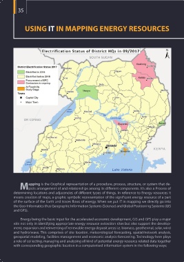
apping is the Graphical representation of a procedure, process, structure, or system that de-
Mpicts arrangement of and relationships among its different components. It’s also a Process of
determining locations and adjacencies of different types of things. In reference to Energy resources it
means creation of maps, a graphic symbolic representation of the significant energy resource of a part
of the surface of the Earth and traces flows of energy. When we put IT in mapping we directly go into
the Geo-Informatics thus Geographic Information Systems (Science) and Global Positioning Systems (GIS
and GPS).
Energy being the basic input for the accelerated economic development, GIS and GPS play a major
role not only in identifying appropriate energy resource extraction sites but also support the develop-
ment, expansion and reinventing of renewable energy deposit areas i.e. biomass, geothermal, solar, wind
and hydro/wave. This comprises of site location, meteorological forecasting, spatial/network analysis,
geospatial modeling, facilities management and economic analysis-forecasting. Technology here plays
a role of collecting, managing and analysing all kind of potential energy resource related data together
with corresponding geographic location in a computerised information system in the following ways;