
Page 282 - Art In The Age Of Exploration (Great Section on Chinese Art Ming Dynasty)
P. 282
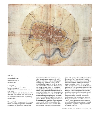
i8i  <
                                                                            around 1502-1503,
           Leonardo da Vinci                           turies, probably dates from employ of Cesare  point, made by using a horizontally mounted sur-
                                                       when Leonardo was in the
           Florentine, 1452-1519                                                                  veying device, such as an astrolabe or circum-
                                                       Borgia as architect and engineer with a special  ferentor.  Some of the linear measurements  along
           MAP   OF IMOLA                              dispensation to visit all the fortifications in  roads are recorded on sketch-maps on  another
                                                       central Italy that Borgia, the  son of Pope Alexan-  drawing at Windsor  (12686). The circle within
           c. 1502-1503                                der vi, was holding as part of his effort  to secure  which the  map of Imola is inscribed is divided into
           pen and ink with watercolor on  paper       and extend the  Papal States.  The technique is  sixty-four parts, and the eight  more heavily  drawn
                    3
                          3
           44 x 60.2 (iy /s  x  23 /4J                 closely related to that employed earlier by Leon  lines are conventionally  labeled with the  names of
           inscribed with notes on distances and the names  Battista Alberti in his map of Rome (now lost), as  the winds:  septantrione  (north), grecho  (north-
           of  the  winds
           references:  Popham  1946, 263;  Clark and  Pedretti  recounted in his Descriptio urbis Romae, and later  east), levante (east), sirocho (southeast), mezzodi
           1968-1969, 12284; Mancini  1979;  London  1989, 98  used by Raphael in his map of Rome (also lost).  It  (south),  libecco (southwest), ponente  (west), and
                                                       results  from  the  coordination  of two sets of mea-  maesto (northwest).  The notes, which record
           Her  Majesty  Queen  Elizabeth n, Royal  Library,  sures: one recording the length of features on the  the  distances of other strategic towns at various
           Windsor  Castle                             ground, obtained either by pacing out distances or  bearings, are written in Leonardo's characteristic
                                                       by using a wheeled measuring device (see Codex  "mirror" script (written  from  right to left  with
           This map (Windsor  12284),  one of the  most  mag-  Atlanticus, ir); and the other  consisting of a  reversed letters), but they are unusually neat and
           nificent  surviving creations of the cartographic  series of records of the  angular positions of fea-  legible, which suggests that they were intended
           revolution of the  fifteenth  and sixteenth  cen-  tures within  a "wind rose" centered on a fixed  to be legible to others.


                                                                                             EUROPE  AND THE  MEDITERRANEAN WORLD     281