
Page 32 - Art In The Age Of Exploration (Great Section on Chinese Art Ming Dynasty)
P. 32
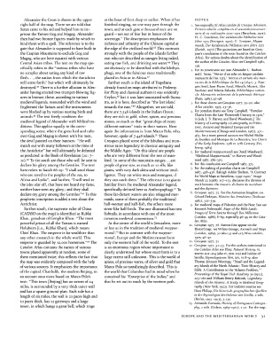
Alexander the Great is shown in the upper at the hour of first sleep or earlier. When it has NOTES
right half of the map. There we are told that finished ringing, no one may pass through the 1. See especially El Atlas Catalan de Cresque Abraham.
Satan came to his aid and helped him to im- town, and at each gate a thousand men are on Primera edition completa en el sexcentesimo aniver-
prison the Tartars Gog and Magog. Alexander guard — not out of fear but in honor of the sario de su realization 1375-1975 (Barcelona, 1975);
Weltatlas vom
Freisleben, Der katalanische
H.-C.
then had two bronze figures made by which to sovereign." The description emphasizes the Jahre 1375 (Stuttgart, 1977); G. Grosjean, Mappa
bind them with a spell. The reference is to the richness and urbanity of the Chinese capital at mundi. Der katalanische Weltatlas vom Jahre 1375
65
gate that Alexander is supposed to have built in the edge of the civilized world. This contrasts (Zurich, 1977) (The quotations are based on Gros-
the Caspian Mountains to exclude Gog and strongly with the people of the islands farther jean's translations of the texts found on the Catalan
Magog, who are here equated with various east who are described as savages living naked, Atlas). For serious doubts about the identification of
66
Central Asian tribes. The text on the map spe- eating raw fish, and drinking sea water. They the author of the Catalan Atlas see Campbell 1981,
116.
cifically refers to the "various tribes who have are obviously to be identified with the Ichthyo- 2. For its provenance see Jean Alexandre C. Buchon
no scruples about eating any kind of raw phagi, one of the fabulous races traditionally and }. Tastu, "Notice d'un atlas en langue catalane
flesh..., the nation from which the Antichrist placed in Asia or in Africa. 67 manuscrit de Pan 1375," Notices et extraits des man-
will come forth/ but which will ultimately be Farther south is the island of Trapobana uscrits de la Bibliotheque du Roi 14 (1841), 3: Fran-
60
destroyed. There is a further allusion to Alex- already found on maps attributed to Ptolemy. c.ois Avril, Jean-Pierre Aniel, Mireille Mentre, Alix
ander having erected two trumpet-blowing fig- For Pliny and classical authors it was evidently Saulnier, and Yolanta Zaluska, Bibliotheque nation-
ale. Manuscrits
enlumines de la peninsule iberique
68
ures in bronze; these, according to various Ceylon, but it was later associated with Suma- (Paris, 1982), 97-98.
medieval legends, resounded with the wind and tra, as it is here, described as "the last island 3. For these sheets see Grosjean 1977, 35-50; also
69
frightened the Tartars until the instruments towards the east." Altogether, we are told, Atlas Catalan, 1975, 23-36.
were blocked up by various nesting birds and there are 7,548 islands in the Indian Ocean; 4. For portolan charts see Tony Campbell, "Portolan
61
animals. The text freely combines the they are rich in gold, silver, spices, and precious Charts from the Late Thirteenth Century to 1500,"
David Woodward,]
J. B. Harvey and
[eds.
in
The
medieval legend of Alexander with biblical tra- stones, so much so that "great ships of many History of Cartography i (Cartography in Prehis-
ditions. This applies equally to the corre- different nations" trade in their waters. Here toric, Ancient and Medieval Europe and the
sponding scene, where the great lord and ruler again the information is from Marco Polo, who, Mediterranean) (Chicago and London, 1987), 371-
70
over Gog and Magog is shown with his men, however, spoke of 7,448 islands. There 463; for a more general account see Michel Mollat
the devil painted on their banners: "He will Cresques placed some of the fabulous and mon- du Jourdain and Monique de La Ronciere, Sea Charts
march out with many followers at the time of strous races legendary in classical antiquity and of the Early Explorers, ijth to iyth Century (Fri-
1984).
bourg,
the Antichrist" but will ultimately be defeated the Middle Ages: "On this island are people 5. For medieval mappaemundi see David Woodward,
as predicted in the Book of Revelation (20: 7- who are very different from the rest of man- "Medieval Mappaemundi" in Harvey and Wood-
62
io). To the south are those who will be sent to kind. In some of the mountain-ranges... are ward 1987, 286-370.
declare his glory among the Gentiles. The text people of great size, as much as 12 ells, like 6. For this conclusion see Campbell 1987, 373.
making
here refers to Isaiah 66:19: "I shall send those giants, with very dark skins and without intel- 7. For the 428-438. of portolan charts see Campbell
1987,
Raleigh Ashlin
"A Contract
Skelton,
who are saved to the peoples of the sea, to ligence. They eat white men and strangers, if for World Maps at Barcelona, 1399—1400," Imago
Africa and Lydia"; and further, "I will send to they can catch them." The reference is to giants Mundi 22 (1968), 107-113, discusses the division of
the isles afar off, that have not heard my fame, familiar from the medieval Alexander legend, work between the maestro di charta da navichare
neither have seen my glory; and they shall specifically defined here as Anthropophagi. To and the dipintore.
71
63
declare my glory among the Gentiles/' To this these far-distant waters are also relegated mer- 8. Grosjean 1977, 75. For the Armenian kingdom see
des Armeniens (Toulouse,
Histoire
Gerard Dedeyan,
prophetic inscription is added a text about the maids, some of them probably the traditional 1982), 307-339.
Antichrist. half-woman and half-fish, the others more 9. For medieval maps of Palestine and the Near East see
Farther south, the supreme ruler of China siren-like half-birds. The one illustrated has two Kenneth Nebenzahl, Maps of the Bible Lands.
(CATAYO on the map) is identified as Kublai fishtails, in accordance with one of the most Images of Terra Sancta through Two Millennia
Khan, grandson of Genghis Khan: "The most common medieval conventions. 72 (London, 1986), 8-69, especially 46-49 on the Cata-
lan Atlas.
powerful prince of all the Tartars is named At the center of the world is Jerusalem, more -LO. Grosjean 1977, 78. Parrots first appear on the
Holubeim [i.e., Kublai Khan], which means or less as in the tradition of medieval mappae- Ebstorf map; see Wilma George, Animals and Maps
73
Chief Khan. The emperor is far wealthier than mundi. But in contrast with the mappae- (London, 1969), 30 (also 35 and 42);Atlas Catalan,
any other monarch in the whole world. This mundi, Europe and the Mediterranean form 1975, 46-47.
64
emperor is guarded by 12,000 horsemen/' The only the western half of the world. To the east 11. Grosjean 1977, 52
mentioned
Catalan Atlas contains the names of various is an enormous region whose importance is 12. Grosjean 1977, 52-53. For the authors History, vi, in
Catalan Atlas see Pliny, Natural
the
towns placed apparently at random, some of clearly understood but whose exact form is to a xxxvu. 202-204 (also iv, xxn. 119) and Isidore of
them mentioned twice; this reflects the fact that large extent still unknown. This is the world of Seville, Etymologiarum libri, xiv, vi:8~9; also
the map was evidently composed with the help spices, of precious wares, of silver and gold that Thomas Johnson Westropp, "Brasil and the Legend-
of various sources. It emphasizes the importance Marco Polo so tantalizingly described. This is ary Islands of the North Atlantic: Their History and
of the capital, Chanbalik, the modern Beijing, in the world that Columbus had in mind when he Fable. A Contribution to the 'Atlantis Problem/"
the
Royal Irish Academy
Proceedings
of
30
(1912),
an account once more based on Marco Polo's conceived his "Enterprise of the Indies," and 223-260 and William Henry Babcock, Legendary
text: "This town [Beijing] has an extent of 24 that he set out to reach by the western path. Islands of the Atlantic. A Study in Medieval Geog-
miles, is surrounded by a very thick outer wall raphy (New York, 1922). For Isidore's sources see
and has a square ground-plan. Each side has a Hans Philipp, Die historisch-geographischen Quellen
length of six miles, the wall is 20 paces high and in der Etymologiae des Isidorus von Sevilla, 2 vols.
10 paces thick, has 12 gateways and a large 13. (Berlin, 1912-1913), 2:135. of Portuguese Cartogra-
Cortesao, History
Armando
tower, in which hangs a great bell, which rings phy, 2 vols. (Lisbon, 1969-1971), 2:72. For the map-
EUROPE AND THE MEDITERRANEAN WORLD 31