
Page 61 - Volume 3 - Walks In The Black Range
P. 61
17. Middle Percha Loop
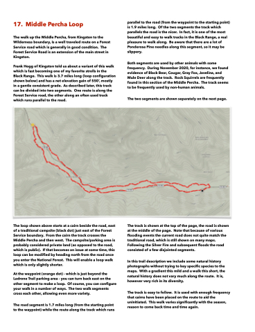
parallel to the road (from the waypoint to the starting point) is 1.9 miles long. Of the two segments the track which parallels the road is the nicer. In fact, it is one of the most beautiful and easy to walk tracks in the Black Range, a real pleasure to walk along. Be aware that there are a lot of Ponderosa Pine needles along this segment, so it may be slippery.
Both segments are used by other animals with some frequency. During November 2020, for instance, we found evidence of Black Bear, Cougar, Gray Fox, Javelina, and Mule Deer along the track. Rock Squirrels are frequently found in this section of the Middle Percha. The track seems to be frequently used by non-human animals.
The two segments are shown separately on the next page.
The walk up the Middle Percha, from Kingston to the Wilderness boundary, is a well traveled route on a Forest Service road which is generally in good condition. The Forest Service Road is an extension of the main street in Kingston.
Frank Hogg of Kingston told us about a variant of this walk which is fast becoming one of my favorite strolls in the Black Range. This walk is 3.7 miles long (loop configuration shown below) and has a net elevation gain of 550’, mostly in a gentle consistent grade. As described later, this track can be divided into two segments. One route is along the Forest Service road, the other along an often used track which runs parallel to the road.
The loop shown above starts at a cairn beside the road, east of a traditional campsite (black dot) just east of the Forest Service boundary. From the cairn the track crosses the Middle Percha and then west. The campsite/parking area is probably considered private land (as opposed to the road, which is public). If that becomes an issue at some time, this loop can be modified by heading north from the road once you enter the National Forest. This will enable a loop walk which is only slightly shorter.
The track is shown at the top of the page, the road is shown at the middle of the page. Note that because of various flooding events the current road does not quite match the traditional road, which is still shown on many maps. Following the Silver Fire and subsequent floods the road consisted of a few disjointed segments.
In this trail description we include some natural history photographs without trying to key specific species to the maps. With a gradient this mild and a walk this short, the natural history does not vary much along the route. It is, however very rich in its diversity.
The track is easy to follow. It is used with enough frequency that cairns have been placed on the route to aid the uninitiated. This walk varies significantly with the season, reason to come back time and time again.
At the waypoint (orange dot) - which is just beyond the Ladrone Trail parking area - you can turn back east on the other segment to make a loop. Of course, you can configure your walk in a number of ways. The two walk segments cross each other, allowing even more variety.
The road segment is 1.7 miles long (from the starting point to the waypoint) while the route along the track which runs
