
Page 11 - Vol. 1 Walks In The Black Range - 2nd Edition
P. 11
and fracture zone...Other old workings on this vein system (ed.: Wicks Canyon) include the Black Peak mine, opened by tunnels and shafts on the south slope of Black Peak.” (pp. 157-158)
The summit area of Black Peak, northeast of Hillsboro, New Mexico, was extensively mined, as late as the early 1950’s. Most of the trenching and other mining is now caved but beams are still easily found along the eastern edge of the peak (photos below).
Diggings near the summit of Black Peak, east of Hillsboro, New Mexico, USA.
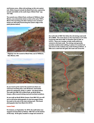
the north side of NM-152, follow the old mining road north (N to NNW). The route shown on the map below is 3.9 miles round-trip with about 600’ of elevation gain (5,366’ to 5,975’). There are a number of side routes which are variants to this basic walk. The mining road generally provides unobstructed walking, in places it is washed out and stones in the roadway may create footing problems. A little over a mile from the gate, this route cuts across the
Summit of Black Peak
As you travel up the road to the summit area there are numerous trenching sites, road off-shoots, and leveled places for equipment, sheds, or cabins - see photo below. The walk from NM-152 to Black Peak, up North Wicks Canyon, offers several mining road and overland variations.
As you walk up North Wicks Canyon, from NM-152, you will see an old house (photographs on next two pages) along the wash to the east of the main mining road. (The house photographs date from March 22, 2014.)
Lower Peak
For instance, on September 12, 2014, the walk below was mapped and described as follows: NM-152 is at the bottom of this map. At the gate, located in a large turn-around on
