
Page 39 - Advanced Biblical Backgrounds Revised
P. 39
The Lesson ...
Ancient Mesopotamia and Abraham.
The location of the inhabitants of the Promised land requires multiple levels of explanation. The biblical
reader must understand what the land looked like before and after the conquests. Before the
conquests, the peoples who inhabited the land had built up major defensive cities. Genesis 10:15-19
names the people groups in the Canaan area that descended from Canaan:
“Canaan fathered Sidon his firstborn and Heth, and the Jebusites, the Amorites, the
16
Girgashites, the Hivites, the Arkites, the Sinites, the Arvadites, the Zemarites, and the
18
17
Hamathites. Afterward, the clans of the
Canaanites dispersed. And the territory of
19
the Canaanites extended from Sidon in the
direction of Gerar as far as Gaza, and in the
direction of Sodom, Gomorrah, Admah, and
Zeboiim, as far as Lasha. (ESV)
75
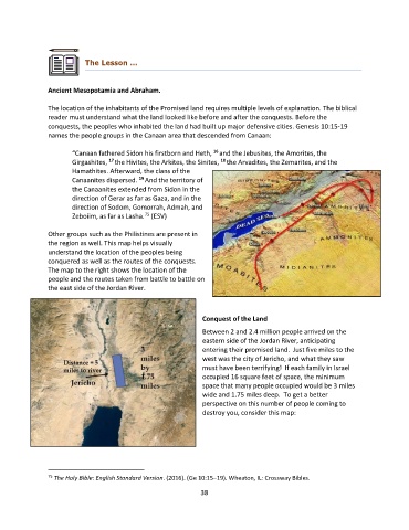
Other groups such as the Philistines are present in
the region as well. This map helps visually
understand the location of the peoples being
conquered as well as the routes of the conquests.
The map to the right shows the location of the
people and the routes taken from battle to battle on
the east side of the Jordan River.
Conquest of the Land
Between 2 and 2.4 million people arrived on the
eastern side of the Jordan River, anticipating
entering their promised land. Just five miles to the
west was the city of Jericho, and what they saw
must have been terrifying! If each family in Israel
occupied 16 square feet of space, the minimum
space that many people occupied would be 3 miles
wide and 1.75 miles deep. To get a better
perspective on this number of people coming to
destroy you, consider this map:
75 The Holy Bible: English Standard Version. (2016). (Ge 10:15–19). Wheaton, IL: Crossway Bibles.
38