
Page 20 - vermeer.pages copy 2
P. 20
Charlotte Mason Picture Study Aid Johannes Vermeer
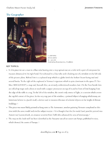
!e Geographer
c. 1668-1669
oil on canvas
52&+&45.5 cm
Städelsches Kunstinstitut, Frankfurt
KEY TOPICS:
• In this piece we see a man in a blue robe leaning over a map spread-out on a table with a pair of compasses (to
measure distances) in his right hand. He is dressed in a blue robe and is looking out of a window on the le) side
of the picture plane. Behind him is a cupboard atop which is a globe (with the Indian Ocean facing out) and
several books. To the right of the cupboard is Vermeer’s signature which is "uite dominant in the space (“I. Ver-
Meer MDCLXVIIII”), a map and, beneath that, an ornately embroidered wooden chair. On the (oor beside him
are rolled-up maps and a chest or stool with a copper protractor on top of it and in front of him hanging from
the edge of the table is a rug. To the le) of the window, the room’s only source of light, is a curtain which covers
the top le) corner of the piece. In the very top part of the window, a pointed object is hanging which many art
historians believe is a Jacob’s sta$, a device used to measure distance of celestial objects or the height of distant
buildings. 5
• !is piece was most likely painted to hang next to !e Astronomer, another painting Vermeer completed at this
time with the same model and similar subject matter. It is thought that the the model (and possible patron) was
5
Antoni van Leeuwenhoek, an amateur scientist from Del) who advanced the area of microscopy. 6
• !e map on the back wall has been identi%ed as the Pascaarte van all zee-custen van Europa, published in 1600,
which showed the coasts of Europe. 5
ahumbleplace.com # Page of 20 25