
Page 7 - Skymap
P. 7
6 7
ENGINEERING & AGRICULTURE ENVIRONMENTAL
CONSTRUCTION PROTECTION
If precision technology drove the farming
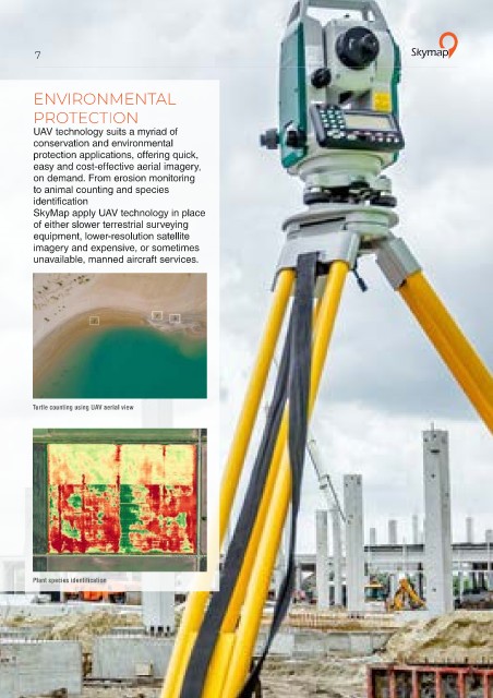
revolution of recent years, monitoring UAV technology suits a myriad of
The time- and cost-saving benefits conservation and environmental
of collecting geospatial data by UAV crops from the sky using drones will drive protection applications, offering quick,
are being realised by an increasing the next, as agronomists, agricultural easy and cost-effective aerial imagery,
number of construction and engineering engineers and farmers turn to UAVs on demand. From erosion monitoring
operations—SkyMap uses UAV to gain better crop insights and more to animal counting and species
technology to monitor a site’s evolution, accurately plan and manage their identification
measure cut and fill volumes, inspect operations. SkyMap apply UAV technology in place
infrastructure or generate accurate 3D SkyMap technology adds value throughout of either slower terrestrial surveying
building models. the growing season, from monitoring equipment, lower-resolution satellite
From measuring cut and fill volumes, emergence right through to pre-harvest imagery and expensive, or sometimes
to conducting precise pre- and as- yield prediction and drainage planning for unavailable, manned aircraft services.
built surveys, and inspecting crucial the next season.
infrastructure, professional drones are
being employed right across the industry.
Turtle counting using UAV aerial view
Infrastructure Inspection
Crop monitoring
3D building model Yield prediction from health analysis Plant species identification