
Page 64 - Green - Maritime Archaeology: A Technical Handbook. 2nd ed
P. 64
Chapter 3: Search and Survey 43
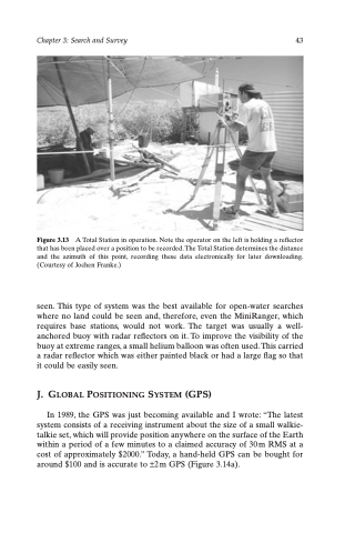
Figure 3.13 A Total Station in operation. Note the operator on the left is holding a reflector that has been placed over a position to be recorded. The Total Station determines the distance and the azimuth of this point, recording these data electronically for later downloading. (Courtesy of Jochen Franke.)
seen. This type of system was the best available for open-water searches where no land could be seen and, therefore, even the MiniRanger, which requires base stations, would not work. The target was usually a well- anchored buoy with radar reflectors on it. To improve the visibility of the buoy at extreme ranges, a small helium balloon was often used. This carried a radar reflector which was either painted black or had a large flag so that it could be easily seen.
J. GLOBAL POSITIONING SYSTEM (GPS)
In 1989, the GPS was just becoming available and I wrote: “The latest system consists of a receiving instrument about the size of a small walkie- talkie set, which will provide position anywhere on the surface of the Earth within a period of a few minutes to a claimed accuracy of 30m RMS at a cost of approximately $2000.” Today, a hand-held GPS can be bought for around $100 and is accurate to ±2 m GPS (Figure 3.14a).
