
Page 29 - Marine Magnetometer Processing
P. 29
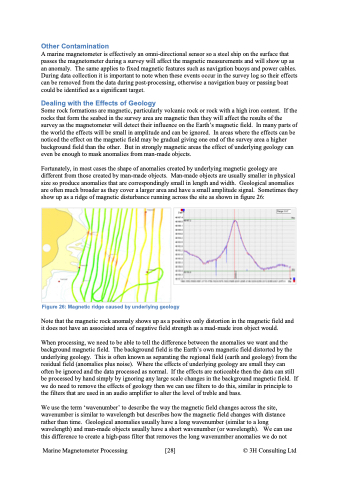
Other Contamination A marine magnetometer is effectively an omni-directional sensor so a steel ship on the surface that passes the magnetometer during a survey will affect the magnetic measurements and will show up as an anomaly. The same applies to fixed magnetic features such as navigation buoys and power cables. During data collection it is important to note when these events occur in the survey log so their effects can be removed from the data during post-processing, otherwise a navigation buoy or passing boat could be identified as a significant target. Dealing with the Effects of Geology Some rock formations are magnetic, particularly volcanic rock or rock with a high iron content. If the rocks that form the seabed in the survey area are magnetic then they will affect the results of the survey as the magnetometer will detect their influence on the Earth’s magnetic field. In many parts of the world the effects will be small in amplitude and can be ignored. In areas where the effects can be noticed the effect on the magnetic field may be gradual giving one end of the survey area a higher background field than the other. But in strongly magnetic areas the effect of underlying geology can even be enough to mask anomalies from man-made objects. Fortunately, in most cases the shape of anomalies created by underlying magnetic geology are different from those created by man-made objects. Man-made objects are usually smaller in physical size so produce anomalies that are correspondingly small in length and width. Geological anomalies are often much broader as they cover a larger area and have a small amplitude signal. Sometimes they show up as a ridge of magnetic disturbance running across the site as shown in figure 26: Note that the magnetic rock anomaly shows up as a positive only distortion in the magnetic field and it does not have an associated area of negative field strength as a mad-made iron object would. When processing, we need to be able to tell the difference between the anomalies we want and the background magnetic field. The background field is the Earth’s own magnetic field distorted by the underlying geology. This is often known as separating the regional field (earth and geology) from the residual field (anomalies plus noise). Where the effects of underlying geology are small they can often be ignored and the data processed as normal. If the effects are noticeable then the data can still be processed by hand simply by ignoring any large scale changes in the background magnetic field. If we do need to remove the effects of geology then we can use filters to do this, similar in principle to the filters that are used in an audio amplifier to alter the level of treble and bass. We use the term ‘wavenumber’ to describe the way the magnetic field changes across the site, wavenumber is similar to wavelength but describes how the magnetic field changes with distance rather than time. Geological anomalies usually have a long wavenumber (similar to a long wavelength) and man-made objects usually have a short wavenumber (or wavelength). We can use this difference to create a high-pass filter that removes the long wavenumber anomalies we do not Figure 26: Magnetic ridge caused by underlying geology Marine Magnetometer Processing \[28\] © 3H Consulting Ltd
