
Page 41 - Marine Magnetometer Processing
P. 41
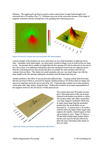
Software. The regular grid can then be used to create contour lines of equal field strength or be converted into a 3D surface (Fig. 37). Problems can occur in the conversion because of the shape of magnetic anomalies and the assumptions of the gridding and contouring process. Figure 37A and B: Contour plot and equivalent 3D representation A good example of the problem can occur when there are two small anomalies on adjacent survey lines. Anomalies from small targets are often nearly circular in shape so are as wide as they are long in size. An anomaly that is smaller in length than the line spacing will only be detected on one survey line, but as there is no additional information about the anomalies between the two adjacent survey lines the contouring process may assume that they are actually the same anomaly and will join contours between them. This makes two small anomalies into one very much longer one with the same length as the line spacing, making the anomalies look far larger than they are. Another problem is the effect of uncorrected and unfiltered data. Creating contour plots from data that has not been levelled or corrected for diurnal variation produces 3D surfaces that are lumpy and uneven in long lines across the survey area (Fig. 38). Using data that contains wave noise produces colour plots with ‘tiger stripes’ along the lines. Neither plot would be an accurate representation of the magnetic field over the site and are of little practical use. Figure 38: Poorly processed magnetometer data (Anon.) The contour plots and 3D models can also give a false impression of the site in areas cluttered with modern iron debris or cables. The modern debris and cables can produce very large magnetic anomalies which may be many times larger than the anomalies produced by the wreck debris we are interested in. A contour plot or 3D surface scaled to show the larger clutter targets may suppress the smaller, wanted targets so they can no longer be seen. Figure 35 shows a 3D plot that includes large modern debris but the scale used for the plot effectively hides the more interesting older targets as they are small. Marine Magnetometer Processing \[40\] © 3H Consulting Ltd
