
Page 12 - TVH 2000 Anniversary Shipwreck Project
P. 12
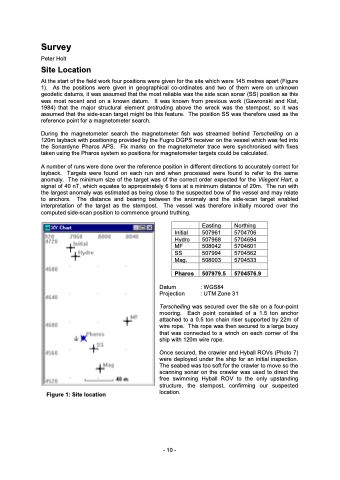
Survey Peter Holt Site Location At the start of the field work four positions were given for the site which were 145 metres apart (Figure 1). As the positions were given in geographical co-ordinates and two of them were on unknown geodetic datums, it was assumed that the most reliable was the side scan sonar (SS) position as this was most recent and on a known datum. It was known from previous work (Gawronski and Kist, 1984) that the major structural element protruding above the wreck was the sternpost, so it was assumed that the side-scan target might be this feature. The position SS was therefore used as the reference point for a magnetometer search. During the magnetometer search the magnetometer fish was streamed behind Terschelling on a 120m layback with positioning provided by the Fugro DGPS receiver on the vessel which was fed into the Sonardyne Pharos APS. Fix marks on the magnetometer trace were synchronised with fixes taken using the Pharos system so positions for magnetometer targets could be calculated. A number of runs were done over the reference position in different directions to accurately correct for layback. Targets were found on each run and when processed were found to refer to the same anomaly. The minimum size of the target was of the correct order expected for the Vliegent Hart, a signal of 40 nT, which equates to approximately 6 tons at a minimum distance of 20m. The run with the largest anomaly was estimated as being close to the suspected bow of the vessel and may relate to anchors. The distance and bearing between the anomaly and the side-scan target enabled interpretation of the target as the sternpost. The vessel was therefore initially moored over the computed side-scan position to commence ground truthing. Figure 1: Site location Initial Hydro MF SS Mag. Pharos Datum Projection Easting Northing 507961 5704706 507968 5704694 508042 5704601 507994 5704562 508003 5704533 507979.5 5704576.9 : WGS84 : UTM Zone 31 Terschelling was secured over the site on a four-point mooring. Each point consisted of a 1.5 ton anchor attached to a 0.5 ton chain riser supported by 22m of wire rope. This rope was then secured to a large buoy that was connected to a winch on each corner of the ship with 120m wire rope. Once secured, the crawler and Hyball ROVs (Photo 7) were deployed under the ship for an initial inspection. The seabed was too soft for the crawler to move so the scanning sonar on the crawler was used to direct the free swimming Hyball ROV to the only upstanding structure, the sternpost, confirming our suspected location. - 10 -
