
Page 12 - 2000 AMA Alps
P. 12
fc*
% -m *
N^flletschhoFRr^ita
ByJonathanBarnett
Dates: 24/25 July 2000
Valley base: Fiesch.
Start point Eggishom.
Mountain hut Mittelaletsch Bivouac Hut. Description of route:
Summit we retraced our steps back to the bivi hut reaching it at about 1,30pm. Atthispointwebelievedthatwewouldbeabletocatchthelast cablecarbacktoFiesch(6.30pm)foranearlyeveningdrink! Wesetoff at about 2pm and made fast progress down the now very soft snow glissadingtothemorainethathadbeenascendedthedaybefore. Once on the glacier we made quick progress to the mouth of the valley to rejoin the Aletsch Glacier at about 3pm. We opted for a different route back to avoid the soul-destroying moraine walk that we had encountered the day before. We went straight onto the glacier heading directly SE heading to the right of the Eggishorn summit to the far side of the Glacier and then walkedN/NEfollowingtheedgeoftheglacier. Thebestrouteisamatter ofchoice! Onthewayouttherouteacrosstheglacierwaseasierbutleft a difficult traverse of the moraine. The return journey was hillier but avoidedthemoraine-takeyourchoice! WereachedtheGletscherstube at 4.20 which gave us 2 hours to get back for the final cable car down
fromKuhboden. TherewasasteepclimbtothetopoftheTalligratridge (2610m) which we reached at about 5pm, before descending down to the cable car at Kuhboden which took us another 45 mins.
This was an extremely tiring walk out but one is given a number of options:
1. Do what we did!
2. Stay another night at the Biv, Hut
3. Stay overnight at the Gletsch rstube Hut 4 Stay in a hotel in-’Kuhboden
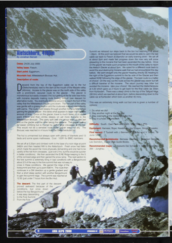
Descend from the top of the Eggishom cable car to the hut (Gletscherstube) next to the dam at the mouth of the Marjele valley (45mins). Access to the glacier was on the north side of the valley
with a prominent, secured route to the glacier. The glacier is
monotonous but easily crossed (1hr) but getting at the far side was tricky with moraine deposits making route finding difficult (see descent for alternativeroute). Youeventuallytraversearoundtoreachthefootofthe valley that the Mittelaletsch Glacier runs down The first part of the valley was gentle with a grassy section and the route was marked intermittently with cairns. The route rises steeply through another moraine field before gaining the glacier proper - this takes what appears to be an interminable amount of time. Once on the glacier, travel is much faster up to about point 2791m and then climbs steeply on yet more moraine to the Mittelaletsch Bivouac. The party split and one group went up this last part on the glacier and the other taking the moraine. The glacier makes for easier climbing but is marred by some large crevasses at the top This would not be a sensible route if the glacier were not dry. The Bivouac was reached in 4 hours from the Gletscherstube hut.
The hut is unmanned but always open with plenty of blankets and 13 beds and some spare mattresses. Cost - 10SFr for BMC members.
We set off at 5.20am and climbed north to the base of a rock ridge at point 3482m and then headed NW to the Aletschjoch. Fresh snow had fallen which made the ascent far more physically demanding and one had to be carefuloftheriskfromcrevasses, (justover2hrs,butthiswouldbequicker inbetterconditions). WethenascendedtheE/NERidgekeepingtotheS ofthecornicededgeandthengainedthesnowramp. Thisnextsectionto the fore summit is extremely tiring in bad conditions with a Bergschrund about 2/3 of the way to the fore summit that was not easy to
cross in these conditions. We gained the ridge of the foresummitandthenuptopoint4087m. Theroutethen continues in a SW direction up a gentle gradient and then a short steep section with another Bergschrund togainthesummitridge. Thesummitwasreachedat 12.00 (just under 7 hours from the Bivi Hut).
The descent: The first part of the descent proved awkward because of the —- conditions, but once down
below the top Bergschrund
it was easy descending to the Fore Summit. From the Fore
Difficulty: South - East Flank arid North - East Ridge (PD). A
Equipment: Harness; Rope; Karabiners; Ice Screws; Slings* Prussiks. First ascent: F Tuckett with J Bennen,'P Bohren and V Tanfaz, '18
June 1859. * . t- Recommended guidebooks: Bernese Oberland -
Les Swindon, Alpine Club Guide Books.
Recommended maps: Landeskarte Der Schweiz 1: 264 - Jungfrau.
Nick On Andy Lennard and Ruaraidh Hill ascending llie Monch.
