
Page 5 - Topic 1 - introduction to gis
P. 5
Vector and Raster Models
Geographic information systems work with two fundamentally different types of
geographic models--the "vector" model and the "raster" model. In the vector model,
information about points, lines, and polygons is encoded and stored as a collection
of x,y coordinates. The location of a point feature, such as a bore hole, can be
described by a single x,y coordinate. Linear features, such as roads and rivers, can
be stored as a collection of point coordinates. Polygonal features, such as sales
territories and river catchments, can be stored as a closed loop of coordinates.
. A raster image comprises a collection of grid cells rather like a scanned map or
picture. Both the vector and raster models for storing geographic data have unique
advantages and disadvantages. Modern GISs are able to handle both models.
Vector
One way of representing geographic phenomena is with points, lines, and polygons.
This kind of representation of the world is generically called a vector data model.
Vector models are particularly useful for representing and storing discrete features
such as buildings, pipes, or parcel boundaries. but less useful for describing
continuously varying features such as soil type or accessibility costs for hospitals.
Points
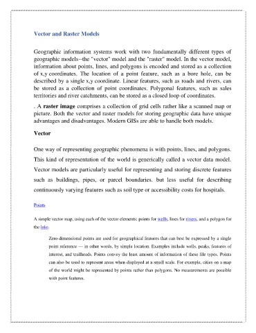
A simple vector map, using each of the vector elements: points for wells, lines for rivers, and a polygon for
the lake.
Zero-dimensional points are used for geographical features that can best be expressed by a single
point reference — in other words, by simple location. Examples include wells, peaks, features of
interest, and trailheads. Points convey the least amount of information of these file types. Points
can also be used to represent areas when displayed at a small scale. For example, cities on a map
of the world might be represented by points rather than polygons. No measurements are possible
with point features.