
Page 11 - D
P. 11
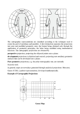
The cartographic representations are classified according to the technique used to
create the grid of meridians and parallels. A first distinction separates the projections
into pure and modified geometric ones, the former being obtained only through the
application of geometric principles, the latter being modified using mathematical
functions. The cartographic projections are obtained by
perspective projection, projecting the ellipsoid points onto a plane;
development projections (cylindrical and conical), projecting onto auxiliary geometric
surfaces that can be developed into a plane;
Pure geometric projections, e.g. the polar stereographic one, are currently
Scarcely used.
In general, maps are nowadays generated through analytical projections: Mercator,
Gauss (UTM), Lambert representations, developed mathematically.
Example of Cartographic Projections

                                            Gauss Map

                                                                11