
Page 16 - D
P. 16
Ch.8
Geographic Information System (GIS)
A broadly accepted definition of GIS is the one provided by the National Centre of
Geographic Information and Analysis: a GIS is a system of hardware, software and
procedures to facilitate the management, manipulation, analysis, modelling,
representation and display of georeferenced data to solve complex problems regarding
planning and management of resources (NCGIA, 1990)
Geographic information systems are now used for land use planning, utilities
management, ecosystems modelling, landscape assessment and planning,
transportation and infrastructure planning, market analysis, visual impact analysis,
facilities management, tax assessment, real estate analysis and many other applications.
Functions of GIS include: data entry, data display, data management, information
retrieval and analysis.
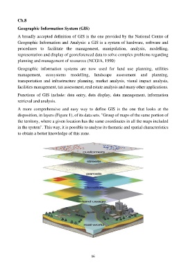
A more comprehensive and easy way to define GIS is the one that looks at the
disposition, in layers (Figure 1), of its data sets. "Group of maps of the same portion of
the territory, where a given location has the same coordinates in all the maps included
in the system". This way, it is possible to analyse its thematic and spatial characteristics
to obtain a better knowledge of this zone.
16