
Page 17 - D
P. 17
Geospatial data
Geospatial data has both spatial and thematic components. Conceptually, geographic
data can be broken up in two elements: observation or entity and attribute or
variable. GIS have to be able to manage both elements.
Spatial component: The observations have two aspects in its localisation: absolute
localization based in a coordinates system and topological relationship referred to other
observations. Example:
The Department civil is located at the particular coordinate X,Y, or, located between
Grattan Street and Old Engineering Building. A GIS is able to manage both while
computer assisted cartography packages only manage the absolute one.
Thematic component: The variables or attributes can be studied considering the
thematic aspect (statistics), the locational aspect (spatial analysis) or both (GIS).
Data for GIS applications
Digitized and scanned data
Databases
GPS field sampling of attributes
Remote sensing and aerial photography
Digital representation of geospatial data
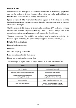
The advantages of digital versus analogue data are outlined in the table below:
17