
Page 68 - Atlas Sea Birds Ver1
P. 68
Cunene River
NAMIBIA
1 20º
2 Ugab River
3 Cape Cross
4 5
21º Swakopmund
6 Walvis Bay
7
8
9 25º
10 11 Lϋderitz
21º 30 12 14 Dorob National Park
13 15 Orange River
16 15º 20º 25º
18
17 19
22º
20
21
22
23
22º 30
13º30 14º 14º30
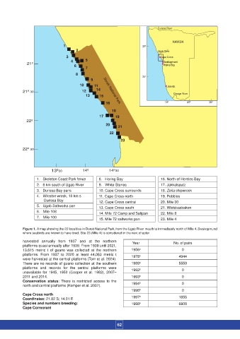
1. Skeleton Coast Park fence 8. Horing Bay 16. North of Henties Bay
2. 6 km south of Ugab River 9. White Stones 17. Jakkalsputz
3. Durissa Bay pans 10. Cape Cross surrounds 18. Zeila shipwreck
4. Winston wreck, 10 km s 11. Cape Cross north 19. Pebbles
Durissa Bay 12. Cape Cross central 20. Mile 30
5. Ugab Saltworks pan 13. Cape Cross south 21. Wlotzkasbaken
6. Mile 108 14. Mile 72 Camp and Saltpan 22. Mile 8
7. Mile 100 15. Mile 72 saltworks pan 23. Mile 4
Figure 1. A map showing the 22 localities in Dorob National Park, from the Ugab River mouth to immediately north of Mile 4, Swakopmund
where seabirds are known to have bred. Site 23 (Mile 4) is considered in the next chapter
harvested annually from 1937 and at the northern Year No. of pairs
platforms quasi annually after 1939. From 1939 until 2021,
13,615 metric t of guano was collected at the northern 1956 a 0
platforms. From 1937 to 2020 at least 44,063 metric t 1978 a 4944
were harvested at the central platforms (Tom et al. 2024).
There are no records of guano collection at the southern 1988 b 5559
platforms and records for the central platforms were b
unavailable for 1945, 1950 (Cooper et al. 1982), 2007– 1992 0
2011 and 2014. 1993 b 0
Conservation status: There is restricted access to the b
north and central platforms (Kemper et al. 2007). 1994 0
1996 b 0
Cape Cross north
Coordinates: 21.82 S; 14.01 E 1997 b 1855
Species and numbers breeding: 1998 b 6908
Cape Cormorant
62