
Page 11 - NYS_ESS_03-2021_FLIPBOOKFILE
P. 11
N
D
A
U
N
BOUNDARY LINES IN
BO
N
ES
I
LI
R
Y
A U G M E NTE D R E A LIT Y
AUGMENTED REALITY
BOUNDARY LINES IN AUGMENTED REALITY
By Dennis McKay, LS
Augmented Reality (AR) is here. TV sports fans experience parcel data such as hunters, campers or appraisers, let us first
it as an imaginary line superimposed onto a football field examine some of the pitfalls.
indicating where the ball needs to advance to get a first down.
Glass ™ by Google is a small wearable computer in the form If you jumped ahead of me, you are concerned that the
of conventional glasses with a transparent display that allows Internet’s idea of a parcel corner’s location (coordinates)
workers to view information hands-free. And while AR glasses causes the corner to be superimposed over the ground in the
have a see-through computer display for lenses, other forms “wrong” spot. Admittedly, the superimposed line will never
1
of AR use conventional LED screens with a live camera be “exactly” where the boundary exists. There will always
feed. For instance, many recent land surveying instruments be some level of error or uncertainty in the measurements
allow mapped points and lines to be superimposed over real used to create the data as visualized. We see this using any
time video feeds on data collectors for field staking or other GIS or CAD application to view existing parcel boundaries
surveying tasks. The benefits are obvious: an operator can see layered over satellite imagery. The closer we zoom in, the more
the real world with augmented visual data superimposed onto evident it becomes that the parcel lines are not aligned with
the fences and road centerlines seen in the image. Similarly,
the display. Surveyors are already using augmented reality AR promises to let us see a survey monument superimposed
for quick access to digital data, but AR glasses are evolving, on the surroundings at our feet, yet inherent in that scene will
opening up even more possibilities. Even new smartphones be some agency’s idea (and error) of where the property lines
have stereo cameras and 3-D scanners built in to accommodate are. This mismatch between reality and digital will be more
graphics rendering that appears to project images upon the evident and potentially more misleading with AR than with
surfaces in our surroundings. From Pokémon to monsters previous GIS technologies.
emerging from your living room wall, smart phones support
a variety of virtual or augmented reality games. And coming Surveyors are the true Measurement Scientists.
soon, we will be able to see what that IKEA dining room set Imperfection and Uncertainty is our wheelhouse:
looks like superimposed in our homes before ever visiting a
showroom. Commerce and gaming will continue to drive the The true position of a legal point may never be measured
rapid evolution of these technologies. exactly and a measured bearing and distance between two
points is never perfect. But, once we can conceptualize and
2
accept that exact distances, angles and coordinates are never
perfectly locatable, we can focus on the real value that surveyors
bring to the public: recognizing, evaluating and estimating the
uncertainty of measurement values. This is not nitpicking!
It is a perspective fundamental to our focus on the always-
inexact nature of measurements between monuments. The
conveyance of that information is critical in creating digitally
published parcel locations.
Prior to my retirement from the Bureau of Land Management
(BLM), I spent many years working with the Geographic
Coordinate Database (GCDB). One of the most important
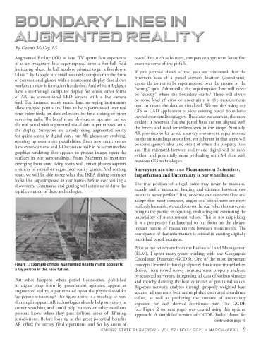
Figure 1: Example of how Augmented Reality might appear to concepts I learned is that digital parcel data is most trusted when
a lay person in the near future. derived from record survey measurements, properly analyzed
by seasoned surveyors, integrating all data of various vintages
But what happens when parcel boundaries, published and thereby deriving the best estimates of positional values.
in digital map form by government agencies, appear as Rigorous network analyses through properly weighted least
augmented reality, superimposed upon the physical world a squares adjustments best accomplishes estimated coordinate
lay person witnessing? The figure above is a mockup of how values, as well as predicting the amount of uncertainty
that might appear. AR technologies already help surveyors in expected for each derived coordinate pair. The GCDB
corner searching and could help hunters or other outdoors (see Figure 2 on next page) was created using this optimal
persons know when they pass to/from areas of differing approach. A simplified version of GCDB, boiled down for
jurisdictions. Before looking at the great potential benefits continued on page 10
AR offers for survey field operations and for lay users of
EMPIRE STATE SURVEYOR / VOL. 57 • NO 2/ 2021 • MARCH/APRIL 9