
Page 12 - NYS_ESS_03-2021_FLIPBOOKFILE
P. 12
usage by the general public, has been formatted in an accepted bearing in mind the x, y uncertainty attributes in GCDB for
national standard for parcel data. This standard is properly this point may be a large ellipse representing a 95% chance
known as the Publication Standard of the Cadastral Theme of that the true corner point falls within that ellipse. With
the Federal Geographic Data Committee (FGDC) National augmented reality however, the stake would already appear
Data Spatial Infrastructure (NSDI), commonly referred to as on your screen as a symbol and the uncertainty ellipse would
the CadNSDI. This data can be found at https://nationalcad. be superimposed, at scale, upon the ground. Ideally, the AR
org/download/PLSS-CadNSDI-Data-Set-Availability. software would also superimpose the connected boundary
pdf. However, this national standard does not include any
measurement data for surveyors to analyze or inspect. It has lines as a wide line, similarly scaled and tangent with the
parcel polygons that are attributed with legal land descriptions ellipse. Perhaps the AR app could be trained to “paint in” all
and a bare minimum of attributes such as official acreage. For the ground a person covered during a search so that he or she
surveyors, it is useful to zoom and pan or otherwise navigate could avoid overlap. And, if survey plat images were indexed
to parcels in an area of interest [and thereby access any openly by geographic location it would be a simple matter to layer
published measurement data]. Notably, there is a point entity relevant plats on the AR display based on where you stand, as
in the CadNSDI at every vertex of each parcel polygon which well as toggling the AR boundary line labels with the different
includes a unique defensible value predicting the reliability of published bearings and distances.
each coordinate value.
Returning to the use by a lay person, consider the difficulty of
Within the GCDB, the range of point uncertainty can be hunters wandering in the woods. The AR glasses could make
dramatic. In modern surveys the uncertainty may be less good use of uncertainty indicators. The jurisdictional lines
than an inch. However, for a few corner coordinate values defining the different hunting zones could be projected onto
in remote areas, the uncertainty is over a quarter of a mile. the ground. A clearly shaded dividing line, perhaps ninety-
This is most often due to misclosing measurements in the feet-wide at one corner of a plot and tapering down to seventy-
ancient-but-best-available survey plats and the lack of nearby feet-wide at the other endpoint, would graphically represent
control points. My point is that this variation in uncertainty an area of uncertainty. A pop-up information window would
must be clearly (and preferably graphically) communicated inform the user that AR boundary lines have uncertainty and
to the end user, especially if the end use is some form of therefore to rely on physical fencing and posting in that zone.
augmented reality. Once inside a jurisdictional area, such as a non-wilderness US
Transitioning to the advantages of AR, just imagine looking Forest Service, a pop-up display could also display other geo-
for a quarter section corner in a remote area. The GCDB or attributes such as the designation for that area along with a list
CadNSDI should already have best-guess coordinates for the of the rules which the hunter or visitor must obey. The same
corner monument and uncertainty indicators. Presently you functionality would be useful for law enforcement personnel.
can be guided to the search area by any GPS device, but in Similarly, real estate agents or property appraisers could better
the near future this guidance will include a corner symbol understand and communicate the extent of land for sale and
projected onto the landscape within your AR display. In a avoid mistakenly placing too much confidence in digital data.
corner recovery, surveyors would normally drive a stake in As Augmented Reality software makes it increasingly easy
the ground at the published coordinates and start searching,
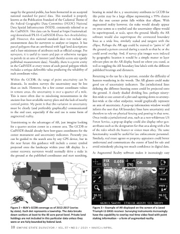
Figure 2 – BLM’s GCDB coverage as of 2012-2017 (varies Figure 3 – Example of AR displayed on the screen of a Javad
by state). Each dot represents a township. The data breaks Triumph LS GNSS receiver. Surveying instruments increasingly
down sections at least to the 40 acre parcel level. Private land have the capability to overlay real time video feed with point
holdings are not included in this particular data unless they staking information – a form of augmented reality.
were or are fully bounded by federal land.
10 EMPIRE STATE SURVEYOR / VOL. 57 • NO 2 / 2021 • MARCH/APRIL