Page 708 - Geosystems An Introduction to Physical Geography 4th Canadian Edition
P. 708
 A-3 Appendix A
Elevations are shown above or below a vertical datum, or reference level, which is usually mean sea level. The con- tour interval is the vertical distance in elevation between two adjacent contour lines (6 m in Figure A.5b).
The topographic map in Figure A.5b shows a hypo- thetical landscape, demonstrating how contour lines and intervals depict slope and relief, which are the three- dimensional aspects of terrain. The pattern of lines and the spacing between them indicate slope. The steeper a slope or cliff, the closer together the contour lines appear—in the figure, note the narrowly spaced contours that represent the cliffs to the left of the highway. A wider spacing of these contour lines portrays a more gradual slope, as you can see from the widely spaced lines on the beach and to the right of the river valley.
The margins of a topographic map contain a wealth of information about its characteristics and content. This includes the map title and number, grid index position, scale, magnetic declination (alignment of magnetic north) and compass information, projection, datum plane, leg- end of symbols, contour interval, date of creation and subsequent updates, and more.
The 1:50000-scale is the most commonly used NTS map series because it is an ideal scale for recreational activities (Figure A.6). At this scale, a typical map sheet in southern Canada covers an area approximately 40 km × 28 km. Hills, valleys, lakes, rivers, streams, rapids, por- tages, trails and wooded areas; major, secondary, and side roads; and all human-made features such as buildings, power lines, dams, and cut lines are accurately represent- ed on these maps. Maps at this scale are used by all levels
of government and industry for flood control, forest-fire control, real-estate planning, natural resources develop- ment, environmental issues, highway planning, and de- piction of crop areas.
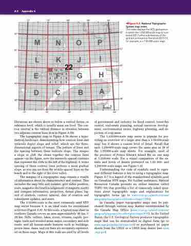
The 1:250000-scale map series is popular for pro- viding an overview of a larger area than a 1:50000-scale map, but it shows a coarser level of detail. Recall that each 1:250000-scale map covers the same area as 16 of the 1:50000-scale map sheets. For example, most of the province of Prince Edward Island fits on one map at 1:250000 scale. For a visual comparison of the ex- tents and levels of details portrayed on 1:50 000- and 1:250000-scale maps, see Figure 1.21.
Understanding the code of symbols used to repre- sent different features is key to using a topographic map. Figure A.7 is a legend of the standardized symbols used on Canadian NTS maps. For further assistance, Natural Resources Canada presents an online seminar called TOPO 101 that provides a list of commonly asked ques- tions about topographic maps and explanations for topographic terms (go to www.nrcan.gc.ca/earth-sciences/ geography/topographic-information/maps/11086).
In Canada, paper topographic maps may be pur- chased through various map dealers recommended by the Canada Map Office (www.nrcan.gc.ca/earth-sciences/ geography/topographic-information/maps/9771). In the United States, the U.S. Geological Survey produces topographic maps that can be downloaded in digital form (go to www.usgs.gov/pubprod/maps.html) or purchased on paper sheets from the USGS or a USGS map dealer (see store .usgs.gov).
6 60 Kilometres
◀Figure A.4 National Topographic System map index.
The index displays the NTS grid system in which the 1:250 000-scale map is num- bered 22F. Further subdivisions of the grid are portrayed in this block (22 F/13, for example, is a 1:50 000-scale map).


