
Page 13 - Garmin Fishfinder Catalog 2021
P. 13
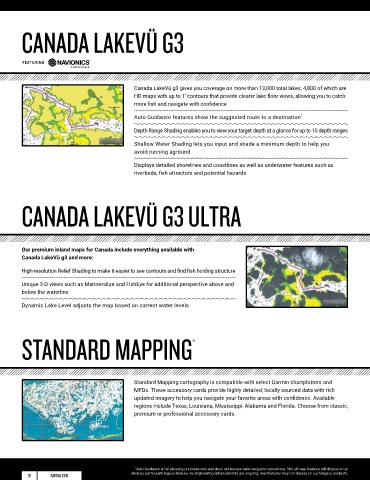
CANADA LAKEVÜ G3


        featuring


                                             Canada LakeVü g3 gives you coverage on more than 13,000 total lakes, 4,800 of which are
                                             HD maps with up to 1’ contours that provide clearer lake floor views, allowing you to catch
                                             more fish and navigate with confidence
                                             Auto Guidance features show the suggested route to a destination 1

                                             Depth Range Shading enables you to view your target depth at a glance for up to 10 depth ranges

                                             Shallow Water Shading lets you input and shade a minimum depth to help you
                                             avoid running aground

                                             Displays detailed shorelines and coastlines as well as underwater features such as
                                             riverbeds, fish attractors and potential hazards


        CANADA LAKEVÜ G3 ULTRA


        Our premium inland maps for Canada include everything available with
        Canada LakeVü g3 and more:

        High-resolution Relief Shading to make it easier to see contours and find fish holding structure

        Unique 3-D views such as MarinersEye and FishEye for additional perspective above and
        below the waterline

        Dynamic Lake Level adjusts the map based on current water levels


        STANDARD MAPPING
                                                                 ®


                                             Standard Mapping cartography is compatible with select Garmin chartplotters and
                                             MFDs. These accessory cards provide highly detailed, locally sourced data with rich
                                             updated imagery to help you navigate your favorite areas with confidence. Available
                                             regions include Texas, Louisiana, Mississippi, Alabama and Florida. Choose from classic,
                                             premium or professional accessory cards.


                                              1 Auto Guidance is for planning purposes only and does not replace safe navigation operations. Not all map features will display on all
          20      GARMIN.COM                devices, particularly legacy devices. As engineering enhancements are ongoing, new features may not display on such legacy products.