
Page 14 - Garmin Fishfinder Catalog 2021
P. 14
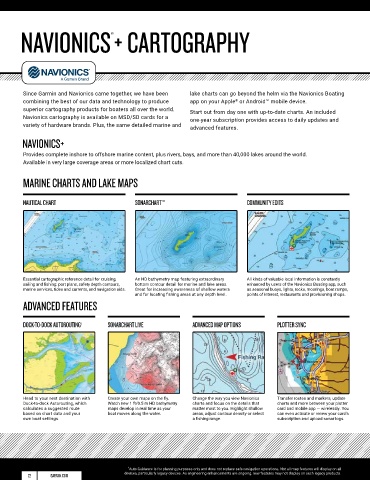
NAVIONICS+ CARTOGRAPHY
                                      ®


         Since Garmin and Navionics came together, we have been   lake charts can go beyond the helm via the Navionics Boating
         combining the best of our data and technology to produce   app on your Apple  or Android™ mobile device.
                                                                               ®
         superior cartography products for boaters all over the world.   Start out from day one with up-to-date charts. An included
         Navionics cartography is available on MSD/SD cards for a   one-year subscription provides access to daily updates and
         variety of hardware brands. Plus, the same detailed marine and   advanced features.

        NAVIONICS+

         Provides complete inshore to offshore marine content, plus rivers, bays, and more than 40,000 lakes around the world.
         Available in very large coverage areas or more localized chart cuts.

         MARINE CHARTS AND LAKE MAPS


         NAUTICAL CHART                       SONARCHART™                          COMMUNITY EDITS


         Essential cartographic reference detail for cruising,   An HD bathymetry map featuring extraordinary   All kinds of valuable local information is constantly
         sailing and fishing: port plans, safety depth contours,   bottom contour detail for marine and lake areas.   enhanced by users of the Navionics Boating app, such
         marine services, tides and currents, and navigation aids.   Great for increasing awareness of shallow waters    as seasonal buoys, lights, rocks, moorings, boat ramps,
                                              and for locating fishing areas at any depth level.   points of interest, restaurants and provisioning shops.
         ADVANCED FEATURES


         DOCK-TO-DOCK AUTOROUTING 1  SONARCHART LIVE             ADVANCED MAP OPTIONS        PLOTTER SYNC


         Head to your next destination with   Create your own maps on the fly.   Change the way you view Navionics   Transfer routes and markers, update
         Dock-to-dock Autorouting, which   Watch new 1 ft/0.5 m HD bathymetry   charts and focus on the details that   charts and more between your plotter
         calculates a suggested route    maps develop in real time as your   matter most to you. Highlight shallow   card and mobile app — wirelessly. You
         based on chart data and your   boat moves along the water.  areas, adjust contour density or select   can even activate or renew your card’s
         own boat settings.                                      a fishing range.            subscription and upload sonar logs.


                                           1 Auto Guidance is for planning purposes only and does not replace safe navigation operations. Not all map features will display on all
          22      GARMIN.COM              devices, particularly legacy devices. As engineering enhancements are ongoing, new features may not display on such legacy products.