
Page 66 - Advanced Bible Geography ebook
P. 66
about 5 miles (8 km.) across and 21 miles (35 km.) long, cut deeply into the earth's crust, displaying a
broad range of colors and rock types.
At the tip of the Negev, near Eilat on the Red Sea, sharp pinnacles of gray and red granite are broken by
dry gorges and sheer cliffs, with colorful layers of sandstone
glowing in the sunlight.
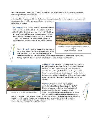
Lake Kinneret (Sea of Galilee), nestled between the hills of
Galilee and the Golan Heights at 695 feet (212 m.) below
sea level, is 8 km. (5 miles) wide and 21 km. (13 miles) long.
It is Israel's largest lake and serves as the country's main
water reservoir. Along Lake Kinneret's shores are some
important historical and religious sites, as well as
agricultural communities, fisheries and tourist facilities.
View from Kinneret village to the lake and Golan
The Jordan Valley and the Arava, along the country Heights
in the east, are part of the Syrian African Rift, which (Photo: Ministry of Tourism)
split the earth's crust thousands of years ago. Its
northern stretches are extremely fertile, while the southern portion is semi-arid. Agriculture,
fishing, light industry and tourism constitute the area's main sources of income.
The Jordan River, flowing from north to south through the
Rift, descends over 2,300 feet (700 m.) in the course of its
186-mile (300 km.) route. Fed by streams from Mount
Hermon, it runs through the fertile Hula Valley into Lake
Kinneret and continues winding through the Jordan Valley
before emptying into the Dead Sea. While it swells during the
winter rainy season, the river is usually quite narrow and
shallow.
The Arava, Israel's savannah region, begins
south of the Dead Sea and extends to the Gulf of
Eilat, Israel's outlet to the Red Sea. Adaptation of
sophisticated farming techniques to climatic
The Hula Valley (Photo: S. Lederhendler) conditions, where the average annual rainfall is less
than one inch (25 mm.) and summer temperatures
soar to 104ºF (40º C), has made it possible to grow out of-season fruit and vegetables, mainly for
export. The sub-tropical Gulf of Eilat, noted for its deep blue waters, coral reefs and exotic
marine life, lies at the southern tip of the Arava.
64