
Page 22 - eatg
P. 22
Enterprise
Location: Intersection of Hwy 1 and 2.
Population: 80. Visitor Information: Enterprise
Regional Tourist Information Centre, 256 Robin
Road, Enterprise, NT X0E 0R1; Phone: (867)
984-3017.
The first major stop after crossing the Alberta/
Northwest Territories border, Enterprise is an excellent
place to regroup for side trips to Hay River, Fort
Resolution and Fort Smith or Wood Buffalo National
Park. The town has a motel and B & B, restaurant and
grocery store. There are also 18 campsites including 9
with power for RVs.
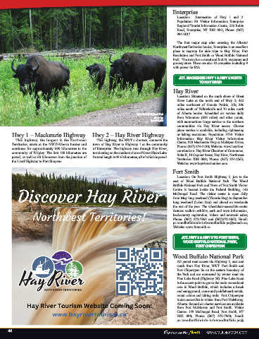
Wood Buffalo National Park
photo by:
Travel Guide JCT. MACKENZIE HWY 1 & HWY 2 NORTH
TO HAY RIVER
Hwy 1 – Mackenzie Highway Hwy 2 – Hay River Highway Hay River
This highway, the longest in the Northwest This highway, the NWT’s shortest, connects the Location: Situated on the south shore of Great
Territories, starts at the NWT/Alberta border and town of Hay River to Highway 1 at the community Slave Lake at the north end of Hwy 2; 462
continues for approximately 690 kilometres to the of Enterprise. The highway runs through Hay River, miles northwest of Grande Prairie, AB; 296
community of Wrigley. The first 188 kilometres are terminating on the southern shore of Great Slave Lake. miles south of Yellowknife and 70 miles north
paved, as well as 60 kilometres from the junction of Its total length is 48.6 kilometres, all of which is paved. of Alberta border. Scheduled air service daily
the Liard Highway to Fort Simpson. from Edmonton (638 miles) and other points,
with summertime barge service to the northern
communities via Hay River access. Charter
plane service is available, including sightseeing
The remainder is gravel, with portions treated for or fishing excursions. Population: 3734. Visitor
dust control. Information: Hay River Visitor Information
Centre, 923 Mackenzie Hwy at McBryan Drive;
Phone: (867) 874-3180; Website: www.hayriver.
com/tourism. Hay River Chamber of Commerce,
Suite K, 10 Gagnier Street, Hay River, Northwest
Territories X0E 0R0; Phone: (867) 874-2565;
Website: www.hayriverchamber.com.
Fort Smith
Location: On Fort Smith Highway 5, just to the
east of Wood Buffalo National Park. The Wood
Buffalo National Park and Town of Fort Smith Visitor
Centre is located inside the Federal Building, 146
McDougal Road. The visitor center is open daily
from May long weekend (Victoria Day) to September
long weekend (Labor Day) and closed on weekends
the rest of the year. The wheelchair-accessible center
features walk-in exhibits, park and town information,
backcountry registration, videos and souvenir sales;
Phone: (867) 872-7960 and (867)872-3065; Email:
pc.woodbuffaloinfo-infowoodbuffalo.pc@canada.ca;
Website: www.fortsmith.ca
JCT. HWY 2 & HWY 5 TO FORT SMITH,
WOOD BUFFALO NATIONAL PARK,
FORT CHIPEWYAN
Wood Buffalo National Park
All paved road access via Highway 5, east and
south from Hay River, NWT. Fort Smith and
Fort Chipewyan lie on the eastern boundary of
the Park and are connected by winter road via
Pine Lake Road (Highway 58). Pine Lake Road
is the access point to get to the main recreational
area in Wood Buffalo, which includes a beach
and campground, canoe and paddleboard rentals,
rental cabins, and hiking trails. Fort Chipewyan
is also accessible in winter from Fort McMurray,
Alberta. Several air charter services are available
from Fort McMurray and Fort Smith. Visitor
Centre: 149 McDougal Road, Fort Smith, NT
X0E 0P0; Phone: (867) 872-7960; Email:
pc.woodbuffaloinfo-infowoodbuffalo.pc@
44