
Page 24 - RMAI Bulletin July - September 2021
P. 24
RMAI BULLETIN JULY TO SEPTEMBER 2021
to respond to these challenges caused by the emergency, in case of planning the shortest route, or
unexpected disaster is quite difficult. GIS based rerouting the fleet as per the cyclonic condition,
location-based system can be used exponentially to planning the service area in case of emergency. GIS can
cope up with such challenges that occurred through be widely used for rescue operation in case of any
natural disasters. critical damages.
Y Identification of probable affected area:
Optimal use of location intelligence and
Natural disasters are the sudden events and the
occurrence of such events can be predicted to certain analytics to improve the services provided
extent, based on the hazards that pose threat to the to citizens and customers
area. As the natural disaster are the rare events, but For forecasting and analyzing the past data and for
the records of the past events can give valuable trends analysis or for the prediction of the events the
information. different statistical methods are used based on the
distribution and the relationship of the data.
Y Migration planning and measurements:
In case of the events of natural disaster the mitigation Data collection of the natural events is quite difficult
planning plays an important role for the safety and as most of the past records are in tabular data. The
security of the lives of the people in the hazardous next challenge is conversion of the data in GIS platform
zone. The risk of the hazardous zone is not same all and the segregation of data based on the events and
over the areas, so in such case the GIS can be used to the intensity of the impacts it has.
demarcate the zones of the high medium and low risk
zones within the area based on which the mitigation Unique value proposition by TROPCYS for
measurements can be planned. Depending upon the emergency response
severity of the natural disaster of the area can be
determined using the GIS Tools. TROPCYC application has been developed for the
prediction or the forecast of the cyclone events that
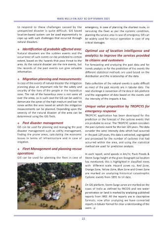
Y Post disaster management are probable to occur. The TROPCYC system considers
GIS can be used for planning and managing the post the past cyclonic event for the last 129 years. The data
disaster management such as utility management, consider the wind intensity data which had occurred
finding the prone areas, calculating the economic in the past 129 years, this data is extracted, segregated
losses in terms of infrastructure and in case of and processed for the number of cyclones that had
irrigation. occurred within the area, and using the statistical
method are used for prediction analysis.
Y Fleet Management and planning rescue
operations In each report, wind speeds in km/hr, Flash Floods &
GIS can be used for planning the fleet in case of Storm Surge height at the given Geographical location
has mentioned, this is highlighted in classified zones
with different scale. Hazard zones viz. Red Zone,
Orange Zone, Yellow Zone, Blue Zone and Green Zone
are marked on analyzing historical catastrophic
Cyclonic events from 1891 to till date.
On GIS platform, Storm Surge zones are marked on the
coast of India as defined by INCOIS and sea water
penetration on land is marked by analyzing published
reports from IMD. All the reports are in descriptive
formats; now after analyzing we have converted
reports in tabular format for clear understanding of the
users. T
22