
Page 79 - New Agent Real Estate training book
P. 79
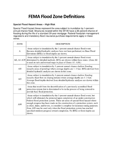
FEMA Flood Zone Definitions


               Special Flood Hazard Areas – High Risk
               Special Flood Hazard Areas represent the area subject to inundation by 1-percent-
               annual chance flood. Structures located within the SFHA have a 26-percent chance of
               flooding during the life of a standard 30-year mortgage. Federal floodplain management
               regulations and mandatory flood insurance purchase requirements apply in these
               zones.


                   ZONE                                      DESCRIPTION

                               Areas subject to inundation by the 1-percent-annual-chance flood event.
                      A       Because detailed hydraulic analyses have not been performed, no Base Flood
                              Elevations (BFEs) or flood depths are shown.
                               Areas subject to inundation by the 1-percent-annual-chance flood event
                AE, A1-A30  determined by detailed methods. BFEs are shown within these zones. (Zone AE
                              is used on new and revised maps in place of Zones A1–A30.)
                               Areas subject to inundation by 1-percent-annual-chance shallow flooding
                     AH       (usually areas of ponding) where average depths are 1–3 feet. BFEs derived from
                              detailed hydraulic analyses are shown in this zone.
                               Areas subject to inundation by 1-percent-annual-chance shallow flooding
                              (usually sheet flow on sloping terrain) where average depths are 1–3 feet.
                     AO
                              Average flood depths derived from detailed hydraulic analyses are shown within
                              this zone.

                               Areas that result from the decertification of a previously accredited flood
                     AR       protection system that is determined to be in the process of being restored to
                              provide base flood protection.

                               Areas subject to inundation by the 1-percent-annual-chance flood event, but
                              which will ultimately be protected upon completion of an under-construction
                              Federal flood protection system. These are areas of special flood hazard where
                              enough progress has been made on the construction of a protection system, such
                    A99
                              as dikes, dams, and levees, to consider it complete for insurance rating purposes.
                              Zone A99 may be used only when the flood protection system has reached
                              specified statutory progress toward completion. No BFEs or flood depths are
                              shown.