
Page 80 - New Agent Real Estate training book
P. 80
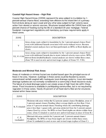
Coastal High Hazard Areas – High Risk
               Coastal High Hazard Areas (CHHA) represent the area subject to inundation by 1-
               percent-annual chance flood, extending from offshore to the inland limit of a primary
               front al dune along an open coast and any other area subject to high velocity wave
               action from storms or seismic sources. Structures located within the CHHA have a 26-
               percent chance of flooding during the life of a standard 30-year mortgage. Federal
               floodplain management regulations and mandatory purchase requirements apply in
               these zones.


                   ZONE                                      DESCRIPTION

                              Areas along coasts subject to inundation by the 1-percent-annual-chance flood
                              event with additional hazards associated with storm-induced waves. Because
                      V
                              detailed coastal analyses have not been performed, no BFEs or flood depths are
                              shown.

                              Areas along coasts subject to inundation by the 1-percent-annual-chance flood
                              event with additional hazards due to storm-induced velocity wave action. BFEs
                VE, V1-V30
                              derived from detailed hydraulic coastal analyses are shown within these zones.
                              (Zone VE is used on new and revised maps in place of Zones V1–V30.)


               Moderate and Minimal Risk Areas
               Areas of moderate or minimal hazard are studied based upon the principal source of
               flood in the area. However, buildings in these zones could be flooded by severe,
               concentrated rainfall coupled with inadequate local drainage systems. Local stormwater
               drainage systems are not normally considered in a community’s flood insurance study.
               The failure of a local drainage system can create areas of high flood risk within these
               zones. Flood insurance is available in participating communities, but is not required by
               regulation in these zones. Nearly 25-percent of all flood claims filed are for structures
               located within these zones.

                    ZONE                                      DESCRIPTION

                                Moderate risk areas within the 0.2-percent-annual-chance floodplain, areas of
                                1-percent-annual-chance flooding where average depths are less than 1 foot,
                                areas of 1-percent-annual-chance flooding where the contributing drainage
                 B, X (shaded)
                                area is less than 1 square mile, and areas protected from the 1-percent-annual-
                                chance flood by a levee. No BFEs or base flood depths are shown within these
                                zones. (Zone X (shaded) is used on new and revised maps in place of Zone B.)

                                Minimal risk areas outside the 1-percent and .2-percent-annual-chance
                     C, X
                  (unshaded)    floodplains. No BFEs or base flood depths are shown within these zones.
                                (Zone X (unshaded) is used on new and revised maps in place of Zone C.)