
Page 11 - Consolidated Catalog
P. 11
With Moniterra, we are the world leaders in providing sophisticated turnkey solutions for
topographic, land, aerial and construction surveying and mapping along with online data
management that includes onsite surveying, data processing and reporting. With varied
experience in geotechnical, geodetic and online solutions, we are now one of the most
formidable group of companies in this field.
Advance Facilities
R&D division
We are leaders in technological advancements with cutting-edge software, instrumentation,
monitoring and manufacturing techniques to address the dynamic requirements of the
evolving construction and environmental sectors.
Quality
Consistent quality services with reliable products, in compliance with the ISO-9001:2015
quality systems conforming to international standards.
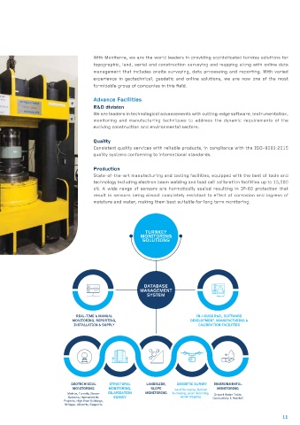
Production
State-of-the-art manufacturing and testing facilities, equipped with the best of tools and
technology including electron beam welding and load cell calibration facilities up to 15,000
kN. A wide range of sensors are hermetically sealed resulting in IP-68 protection that
result in sensors being almost completely resistant to effect of corrosion and ingress of
moisture and water, making them best suitable for long term monitoring.
TURNKEY
MONITORING
SOLUTIONS
DATABASE
MANAGEMENT
SYSTEM
REAL-TIME & MANUAL IN-HOUSE R&D, SOFTWARE
MONITORING, REPORTING, DEVELOPMENT, MANUFACTURING &
INSTALLATION & SUPPLY CALIBRATION FACILITIES
GEOTECHNICAL STRUCTURAL LANDSLIDE, GEODETIC SURVEY ENVIRONMENTAL
MONITORING MONITORING, SLOPE Land Surveying, Optical MONITORING
Metros, Tunnels, Sewer DILAPIDATION MONITORING Surveying, Laser Scanning, Ground Water Table,
Systems, Hydroelectric SURVEY Aerial Mapping Conductivity & Rainfall
Projects, High Rise Buildings,
Bridges, Airports, Seaports
11