
Page 13 - Consolidated Catalog
P. 13
Laser Scanning
It is a method to automatically monitor and collect the data in real time with 3D surface coordinates
of an object in normal grid. Laser scanning is a rapid and reliable surveying method as it collects the
data in static, stop and go or kinematic mode. From the point where cloud is produced, the exported
section profiles can be used to monitor deformations or displacements. Although these are mainly used
in tunnels, they can also be used in structures, landslides and rock-fall areas.
Deformation Monitoring
It is a systematic measurement and monitoring of changes in the shape or dimensions of any structure.
The monitoring procedure includes applied topography and geomechanics and is directly related to civil
engineering, mechanical engineering and rock mechanics. It is useful in application areas like dams,
roads, tunnels, bridges and overpasses, multi-storey and historical buildings, foundations, mining -
exploitation, landslides and sloping, earthquake prone regions.
Topographic and Aerial Mapping using UAVs (Drones)
UAVs are the latest trend in geodesy’s technology for aerial mapping. Unmanned and remotely-piloted
aircrafts that follow a pre-programmed path for take-off, flight and landing. These aircrafts are equipped
with HD/IR/thermal cameras that compute aerial images and videos over a defined area at a specified
height. The point clouds, meshes and 3D models produced are the data to be compared between sequel
flights during monitoring time. This is a very fast, accurate and low cost way to monitor the progress
of any large scale project, where frequent geospatial and/or imaging information is needed, in order to
monitor earthmoving issues or the progress of a running project.
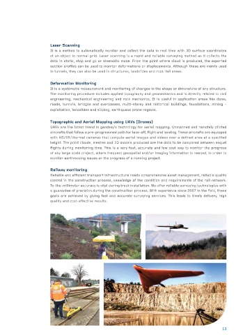
Railway monitoring
Reliable and efficient transport infrastructure needs comprehensive asset management, reliable quality
control in the construction process, knowledge of the condition and requirements of the rail network.
To-the-millimeter accuracy is vital during track installation. We offer reliable surveying technologies with
a guarantee of precision during the construction process. With experience since 2007 in the field, these
goals are achieved by giving fast and accurate surveying services. This leads to timely delivery, high
quality and cost-effective results.
13