
Page 69 - Guía Turismo Activo 2017 en la Serrania de Ronda
P. 69
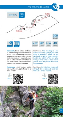
VÍAS FERRATAS: EL HACHO


                         K3
           DIFICULTAD
                         DIFÍCIL


 VÍA FERRATA
 IRON WAY
 Nº6  Miguel A. Mateos                                         300
                                                                 m
                                                               RECORRIDO
 EL HACHO                              3h 30’ 20’      2h 30’ 40’


          EXTRAPLOMO  ESCALA           TIEMPO TOTAL  T. ACCESO  T. FERRATA  T. REGRESO
 Access. You can access from the road
 Municipio / Municipality. Gaucín  which links the village El Colmenar  Breve reseña. La vía ferrata del Hacho  Brief review. This Iron Way is quite
 Pueblo cercano / Nearest town. Gaucín  (Estación de Gaucín) to the road  es bastante exigente físicamente de-  difficult as a very good physical con-
 Localización / Coordinates.  Ronda-Algeciras, approximately at the  bido a los dos extraplomos que en-  dition is required to tackle the two
 x: 289653 y: 4044992  kilometre 2.5. In a curve to the right,  contraremos y a que requieren de una  overhands as well as the cable stairs
 Dificultad / Difficulty.  you will find a path on the left side  cierta habilidad para superar la esca-  fixed in the middle of the Iron Way.
 which will take you to a typical An-  lera de cable instalada a mitad de vía.  Once you have achieved these stairs,
 K3 Difícil / K3 Difficult
 dalusian country house el Cortijo del  Una vez superada esta, alcanzaremos  you will reach the peak El Hacho with
 Recorrido / Itinerary. 300 m
 Peso. Just before you arrive to this  la cima del Hacho sin dificultad.  any difficulties.
 Desnivel / Slope. 100 m
 cortijo, you will come across another
 Tiempo total estimado /
 widen path on the right where you  Restricciones. No conocemos restric-  Restrictions. No restrictions are applied,
 Estimated return time. 3h 30’ ida y
 could park your car. You will walk along  ciones. Atención, se trata de un te-  although it is necessary to be aware
 vuelta desde el aparcamiento / 3
 the marked path towards a forest  rreno privado.  that it is a private property.
 hours 30 mins from the car park
 house and then to the rock walls
 where the Iron Way starts. The return
 will be along the left side towards the  X       X
 Acceso. Se accede desde la carretera  forest house and the car park.  VÍDEO  TRACK
 que une el pueblo de El Colmenar
 (Estación de Gaucín) con la carretera
 Ronda-Algeciras, aproximadamente
 en el kilómetro 2,5. En una curva
                                                         Miguel A. Mateos
 a la derecha encontraremos un
 camino de tierra, a la derecha,
 que nos llevará hasta el Cortijo
 del Peso. Justo antes de llegar
 al cortijo, a la derecha, encon-
 traremos un carril y un ensan-
 chamiento donde podremos
 dejar el coche. Seguiremos el
 camino trazado hasta una casa
 forestal y, desde ahí, siguiendo el
 sendero trazado, llegaremos hasta
 las paredes donde encontraremos el
 inicio de la vía. El regreso lo efectua-
 68  remos hacia la izquierda en busca de                               69
 la casa forestal y el aparcamiento.