Page 74 - Guía Turismo Activo 2017 en la Serrania de Ronda
P. 74

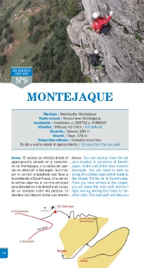
VÍAS FERRATAS: MONTEJAQUE


                                                                                                  K3
                                                                                     DIFICULTAD
                                                                                                   DIFÍCIL


                                                                                                                                         178
                                                                                                                                        m
                                                                                                                                          DESNIVEL
       VÍA FERRATA
         IRON WAY
         Nº9                                                                                                                             258
                                                                                                                                           m
                                                                                                                                         RECORRIDO
               MONTEJAQUE

                                                                                                                  3h     30’     2h      30’
                                                                                   EXTRAPLOMO  TIROLINA          TIEMPO TOTAL  T. ACCESO  T. FERRATA  T. REGRESO
                       Municipio / Municipality. Montejaque
                     Pueblo cercano / Nearest town. Montejaque
                  Localización / Coordinates. x: 299702 y: 4068000
                                                                                   que separa las dos paredes rocosas.  to a separation in the rock walls and
                    Dificultad / Difficulty. K3 Difícil / K3 Difficult
                                                                                   Un descenso abrupto nos llevará hasta  after an abrupt descent, you will arrive
                           Recorrido / Itinerary. 258 m
                                                                                   el pie de vía. La salida la efectuaremos  at the beginning of the Iron Way. The
                            Desnivel / Slope. 178 m
                                                                                   hacia la izquierda, por el sendero mar-  return will be along the marked path
                     Tiempo total estimado / Estimated return time.
                                                                                   cado, hasta encontrar un llano. Rode-  on the left side towards a plain where
           3h ida y vuelta desde el aparcamiento / 3 hours from the car park       mos el llano por la izquierda siguiendo  then you will need to walk around, on
                                                                                   las indicaciones hasta encontrar el  the left side again, and fi nally you will
                                                                                   sendero de acceso y, por este, llegare-  arrive at the chapel and at the car
       Acceso.  El acceso se efectúa desde el  Access. You can access from the car  mos hasta la ermita y el aparcamiento.  park.
       aparcamiento situado en el cemente-  park located in cemetery of Monte-
       rio de Montejaque, a la salida del pue-  jaque, at the end of the town towards  Breve reseña. La vía ferrata de Monte-  Brief review. The Iron Way Montejaque
       blo en dirección a Benaoján. Subimos  Benaoján. You will need to walk up    jaque está considerada muy difícil de-  is considered as very difficult due to
       por el camino empedrado que lleva a  along the cobbled path which leads to  bido a los dos exigentes extraplomos  two tough overhands and, especially,
       la ermita de la Escarihuela. Una vez en  the chapel Ermita de la Escarihuela.  y, sobre todo, por la espectacular tiro-  to a spectacular zip-line stretched
       la ermita dejamos el camino principal  Once you have arrived at the chapel,  lina de 72 m que une las dos pare-  over 70 metres which links the two
       para desviarnos a la derecha en busca  you will leave the main path and turn  des. Es una vía no apta para  walls. It is not recommended to ama-
       de un sendero entre las piedras. El  right looking among the rocks for an-  principiantes y requiere del material  teurs and it requires technical equip-
       sendero nos llevará hasta una brecha  other path. This new path will take you  técnico necesario para cruzar la tiro-  ment to tackle the zip-line.
                                                                                   lina.
                                                                                                                  Restrictions. No restrictions are applied,
                                                                                   Restricciones. No conocemos restric-  although it is necessary to be aware
                                                                                   ciones. Atención, se trata de un te-  that it is a private property, respect
                                                                                   rreno privado, respeta el sendero y las  the path and the signs.
                                                                                   indicaciones.


                                                                                   X                                        X


                                                                                   VÍDEO                                    TRACK
  74                                                                                                                                             75
   69   70   71   72   73   74   75   76   77   78   79