
Page 24 - SAICE book proof 2 LATEST JULY 2014
P. 24
s a i c e
EASTERN CAPE PROVINCE
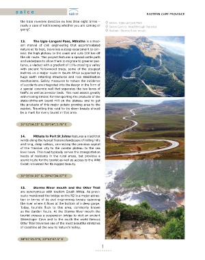
the train reverses direction no less than eight times – ◊ Below: Ugie-Langeni Pass
really a case of not knowing whether you are coming or ◊ Below Centre: Road through Transkei
going”. ◊ Bottom: Storms River mouth
13. The Ugie-Langeni Pass, Mthatha is a mod-
ern marvel of civil engineering that accommodated
nature at its best, traverses a steep escarpment to con-
nect the high plateau to the coast and cuts 100 km off
the old route. This project features a special cattle path
and underpass to allow them to migrate to greener pas-
tures, a viaduct with a gradient of 11% crossing a valley
with ancient Yellowwood trees, some of the steepest
inclines on a major route in South Africa supported by
huge earth retaining structures and rock stabilisation
mechanisms. Safety measures to reduce the incidence
of accidents are integrated into the design in the form of
a special concrete wall that separates the two lanes of
traffic as well as arrestor beds. This road assists greatly
with moving timber, for transporting the products of the
state-of-the-art board mill on the plateau and to get
the products of this major potato growing area to the
market. Travelling this road for its sheer beauty should
be a must for every tourist in this area.
31°12’04.25” S, 28°14’13.78” E
14. Mthata to Port St Johns features a road that
winds along the typical Transkei landscape of rolling hills
and long, deep valleys, connecting the previous capital
of the Transkei city to the coastal plateau to the sea
level town. This road typically serves the transportation
needs of residents in the rural areas, but provides a
scenic route for the tourist as well as access to the Wild
Coast renowned for its rugged beauty.
31°35’10.93” S, 28°47’24.07” E
15. Storms River mouth and the Otter Trail
are synonymous with tourism South Africa. As previ-
ously mentioned the bridge on the N2 is a major attrac-
tion in terms of its civil engineering beauty spanning
the river where it flows at the bottom of a deep gorge.
Today, tourists flock to this area, commonly known
as the Garden Route. At the Storms River mouth the
tourist crosses a suspension bridge to visit an ancient
Strandloper Cave and to the south the world famous
Otter Trail traverses one of the most beautiful stretches
of coastline all the way to Nature’s Valley.
34°01′15.5″S, 23°52′47.5″ E
1