
Page 27 - SAICE book proof 2 LATEST JULY 2014
P. 27
s a i c e
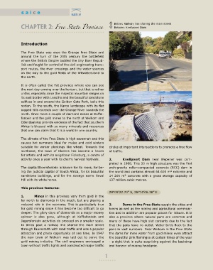
◊ Below: Railway line sharing the main street
CHAPTER 2: Free State Province ◊ Bottom: Knellpoort Dam
Introduction
The Free State was once the Orange Free State and
around the turn of the 20th century the battlefield
where the British Empire tackled the tiny Boer Repub-
liek and fought for control of the civil engineering trans-
port routes, the river crossings and the water sources
on the way to the gold fields of the Witwatersrand to
the north.
It is often called the flat province where you can see
the next day coming over the horizon, but that is rather
unfair, especially since the majestic mountain ranges on
its east border with Lesotho and the beautiful sandstone
edifices in and around the Golden Gate Park, belie this
notion. To the south, the Karoo landscape with its flat
topped hills extends over the Orange River towards the
north. Once more a couple of diamond mines at Koffie-
fontein and the gold mines to the north at Welkom and
Odendaalsrus provide evidence of the fact that southern
Africa is blessed with so many minerals and resources
that one can claim that it is a world in one country.
The climate of the Free State is high savannah and this
causes hot summers ideal for maize and cold winters
suitable for winter plantings like wheat. Towards the circles at important intersections to promote a free flow
northeast, the town of Clarens has become a haven of traffic.
for artists and with its neighbour Ficksburg, a centre of
activity once a year with its cherry harvest festivals. 2. Knellpoort Dam near Wepener was com-
pleted in 1988. This 50 m high structure was the first
The capital Bloemfontein is known for its roses, for be- arch-gravity roller-compacted concrete (RCC) dam in
ing the judicial capital of South Africa, for its beautiful the world and contains almost 64 600 m³ rollcrete and
sandstone buildings, and for the strange name Naval 14 200 m³ concrete with a gross storage capacity of
Hill with its white horse. 137 million cubic metres.
This province features:
29°09’22.70” S, 26°10’06.38” E
1. Mines in this province vary from gold in the
far north to diamonds in the south, but are playing a
reduced role in the economy. This is particularly true 3. Dams in the free State supply the cities and
for gold mining since it has become too difficult to go towns as well as the mining and agricultural communi-
deeper. The glory days of diamonds as a major money ties and in addition are popular places for leisure. It is
spinner is also gone, although at Koffiefontein and also a province where natural pans are common and
Jagersfontein activities do proceed on a smaller scale. many of these have high slat contents due to the fact
In times past a railway line shared the main street that the pans have no outlet. Water birds flock to the
through Fauresmith with road traffic and was a popular pans in vast numbers. Near Welkom in the Free State
attraction and photo opportunity at one time. In 1947 the dams for mine water from gold mines even attract
the new town of Welkom was laid out to serve the the beautiful pink flamingos at certain times of the year
gold mining industry. The civil engineers envisaged a - a sight that is quite surprising against the backdrop
town without traffic lights and constructed major traffic and horizon of mining headgear.
1