
Page 164 - eProceeding - IRSTC & RESPEX 2017
P. 164
Nur Aisah Ab.Moin / JOJAPS – JOURNAL ONLINE JARINGAN COT POLIPD
Figure 1.1: Flowchart of research methodology
3. Data Processing
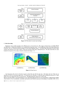
Preliminary study include the study on the different sources of elevation data. The 3 types of data chosen are LiDAR, IFSAR
and SRTM data. LiDAR and IFSAR data are acquired from the private sector. The LiDAR data produce from the airborne data
collection, while the IFSAR data by the purchase of NEXTMap Malaysia dataset. The SRTM data downloaded from the USGS
website with reference to the same location. Total area involved in this study is about 80 hectare. The data must fall in the same
location for the process of accuracy evaluation measurement (figure 1.2)
i) LiDAR Data ii) IFSAR Data iii) SRTM Data
Figure 1.2: Data Sources
The first process, the clip tools function is used to extract the data with the same size. The format and size of the data are
identified for the data processing requirement. This process is very important to reduce the time of data processing and to ensure
all the datasets are represented for the same location. The DEM generated using topo to raster tools.
Then the next procedure is watershed delineation. The watershed delineation involves the determination of Depressionless DEM,
Flow Direction, Flow Accumulation, watershed outlet points and finally the process of delineating the watershed (ESRI, 2014).
162 | V O L 8 - I R S T C 2 0 1 7 & R E S P E X 2 0 1 7