
Page 48 - DILMUN 14
P. 48
where the harborlcanal systcm was present. Furthcrmore, it was possible to
corrclate the variation in the conductivity patterns with architectural variation
obtained from top-plan drawings. Our data suggcsts a clear and significant
relationslip betwecn the mamade fcatures and the variation in the conductivity.
The final data analysis, carricd out at the Smithsonian Institution and at the U.S.
Geological Survey, was made on both 2- and 3-dimensional graphs obtained from
the conductivity data.
INTRODUCTION
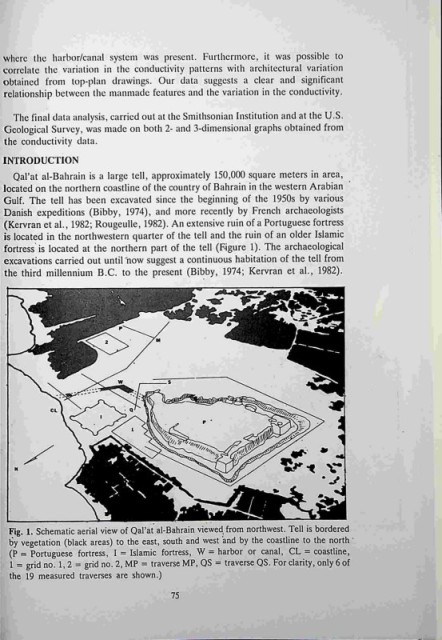
Oal'at al-Bahrain is a large tell, approximately 150,000 square meters in area,
located on the northern coastline of the country of Bahrain in the western Arabian
Gulf. The tell has been excavated since the beginning of the 1950s by various
Danish expeditions (Bibby, 1974), and more recently by French archaeologists
(Kevrran et al., 1982; Rougeulle, 1982). An extensive ruin of a Portuguese fortress
is located in the northwestern quarter of the tell and the ruin of an older Islamic
fortress is located at the northern part of the tell (igure 1). The archaeological
excavations carried out until now suggest a continuous habitation of the tell from
the third millennium B.C. to the present (Bibby, 1974; Kervran et al., 1982).
Fig, 1. Schematic aerial view of Oal'at al-Bahrain viewed from northwest. Tell is bordered
by vegetation (black areas) to the east, south and west adn by the coastline to the north
(P = Portuguese fortress, I = Islamic fortress, W = harbor or canal, CL = coastline,
1 = grid no. 1,2 = grid no. 2, MP = traverse MP, OS = traverse OS. For clarity, only 6 of
the 19 measured traverses are shown.)
75