
Page 477 - Bahrain Gov Annual Reports (IV)_Neat
P. 477
69
Water for irrigation or domestic purposes is obtained cither from an artesian well (natural
pressure or by pumping) or from an open hand-dug well in which case the water is lifted by
animals, or by a small pump. The underground supplies arc designated Water Zone “A”, “B.”
“C” and Shallow or Surface Water Zone. This (latter) zone supplies most of the shallow hand-
dug wells in the north-eastern part of the island, and is not to be confused with Water Zone
“A,” “B" and “C” where these occur near the surface in other localities. It consists of a
perched water body, occurring in loose Quarternary sediments which rest on impervious shale
at a depth below sea level. The water is derived mainly from the deeper aquifers (water
Zones “A” and “B”) by seepage from springs, leaking artesian wells, and by the infiltration of
irrigation water derived from these sources ; a small proportion is also derived from local
rainfalls. A static head of zero plus is maintained by the sea to which these sediments arc
exposed.”(3).
“The water indigenous to water zone “C” is too saline for drinking or irrigation purposes
with the possible exception of the area inside the Rim Rock where an actual water table is
developed in these formations. Data obtained from drilling oil wells during the field develop
ment period indicate the water table to be approximately 22 feet above sea level and, although
variable, salt content increases rapidly from approximately 1,700 ppm. NaCl at the water
surface to approximately 8,000 ppm NaCl in the first 50-75 feet of submergence.”(3)
“Water Zones ‘A’ and ‘B’ are by far the most prolific local water-bearers, and these two
zones encircle the island, yielding artesian water which is suitable for domestic purposes along
the coastal region, and at surface elevations below the static head, from a point approximately
two miles south of Zellaq northward up the west coast, round the north of the Island and down
the cast coast as far as the Refinery to the south. Salinity increases from north to south on
both flanks but more markedly on the east flank. The static head of water in these two zones
also decreases from north to south. South of the points mentioned on the east and west
coasts of the island the water indigenous to these zones is too saline for domestic use.”(3)
The water zones “A,” “B” and “C” correspond to the White Limestone, Brown Crystalline
Limestone and Chalky Zone (respectively) of the Eocene rock strata referred to in Table I.
Agricultural expansion is not likely to be very great, but it has been realised that if there is
to be any expansion the fresh water springs which are prevalent off the north-east coast (and in
other parts) will have to be utilised. The number and location of these springs is now being
checked by BAPCO water engineers, and at time of writing a very productive one has been found
off Muharraq Island.
The total number of artesian wells must be several hundred so that a very considerable
amount of water is being drawn daily. The number of drillings, etc., for the last three years
are as follows :—
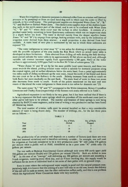
TABLE 3
No. of Wells No. of Wells
Year Drilled Plugged
1949 11 2
1950 14 5
1951 18 12
The productivity of an artesian well depends on a number of factors (and there are even
tidal and seasonal variations) and is therefore extremely variable ; for example, one well used
for irrigation at Gariyah considered to be a very productive zone “B” well yields 470 gallons
per minute while a public well at Hidd, considered to be a poor zone “A” yields only 13J
gallons per minute.
The two wells at Budaiya Experimental Centre although only some 600 yards apart yield
506 gallons per minute (South) and 224 gallons per minute (North). Both arc drilled in zone
“B”. In the case of an “average” well delivering say 300 gallons per minute and assuming a
3-inch irrigation, watering every third day, and an 8-hour working day, this supply would be
sufficient for six acres of cultivated land or ten acres of date palms with no ground crops.
Even in areas where the underground water supply is good and the natural pressure com-
paratively high, it is known that the sinking of a new well near to an old one, lowers the delivery
of the old well to such an extent, that the older cultivation suffers sadly, and this is one problem
which the Agricultural Water Committee deals with very carefully.
!