
Page 122 - Art In The Age Of Exploration (Great Section on Chinese Art Ming Dynasty)
P. 122
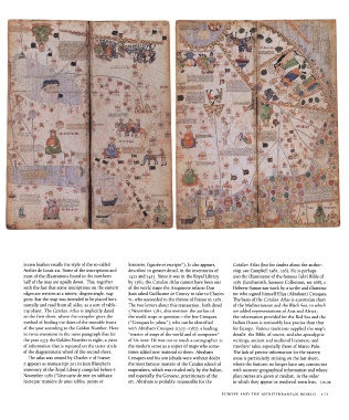
brown leather  recalls the  style of the  so-called  historiee, figuree  et escripte").  It also appears,  Catalan Atlas (but for doubts about the  author-
             Atelier  de Louis xn. Some of the  inscriptions and  described in greater  detail, in the  inventories of  ship, see Campbell 1981,116).  He is perhaps
             most of the illustrations  found in the  northern  1411  and  1413.  Since it was in the  Royal Library  also the  illuminator  of the  famous Fahri Bible of
             half of the  map are upside down.  This,  together  by  1380,  the  Catalan Atlas cannot have been one  1381  (Letchworth, Sassoon Collection, MS 368), a
             with the  fact that some inscriptions on the  eastern  of the world maps the Aragonese infante Don  Hebrew-Samaritan work by a scribe and  illumina-
             edges are written  at a ninety-degree angle,  sug-  Juan asked Guillaume de Courcy to take to  Charles  tor who signed himself  Elic.a (Abraham) Cresques.
             gests that the map was intended to be placed hori-  vi, who succeeded to the throne  of France in  1381.  The basis of the  Catalan Atlas is a portolan  chart
             zontally  and read from  all sides, as a sort  of table-  The two letters  about this transaction, both dated  of the  Mediterranean and the  Black Sea, to which
             top object. The Catalan Atlas is implicitly dated  5 November  1381,  also mention  the author of  are added representations  of Asia and  Africa;
             on the first  sheet, where the compiler gives  the  the  world maps in question — the  Jew Cresques  the information provided for the  Red Sea and  the
             method  of finding the  dates of the  movable  feasts  ("Cresques lo juheu"), who can be identified  Indian Ocean is noticeably less precise than that
             of the year according to the  Golden Number.  Here  with Abraham Cresques (1325-1387), a leading  for  Europe. Various traditions supplied the  map's
             he twice mentions  in the  same paragraph that for  "master  of maps of the  world and  of compasses"  details: the  Bible, of course, and also apocalyptic
             the year  1375  the  Golden Number is eight,  a piece  of his time.  He was not  so much a cartographer in  writings,  ancient and medieval literature,  and
             of information that is repeated on the  outer circle  the  modern  sense as a copier of maps who  some-  travelers' tales, especially those of Marco Polo.
             of the  diagrammatic wheel of the  second  sheet.  times  added new material to them.  Abraham  The lack of precise information for the  eastern
              The atlas was owned by Charles v of France;  Cresques and his son Jehuda were without  doubt  areas is particularly striking on the  last sheet,
             it appears as manuscript 201 in Jean Blanchet's  the  most  famous masters of the  Catalan school of  where the features no longer have any connection
             inventory  of the  Royal Library compiled before 6  mapmakers, which was rivaled only by the  Italian,  with accurate geographical information and where
             November  1380  ("Une carte de mer en tabliaux  and especially the  Genoese, practitioners of the  place names are given at random, in the  order
             faicte par maniere de unes tables, painte et  art. Abraham is probably responsible for the  in which they appear on medieval town  lists.  J.M.M.

                                                                                              EUROPE  AND  THE  MEDITERRANEAN  WORLD    121