
Page 16 - Pipeline JanFebMar2020
P. 16
CIS & GIS UPDATES
by Abigail Staples
Customer Information System (CIS)
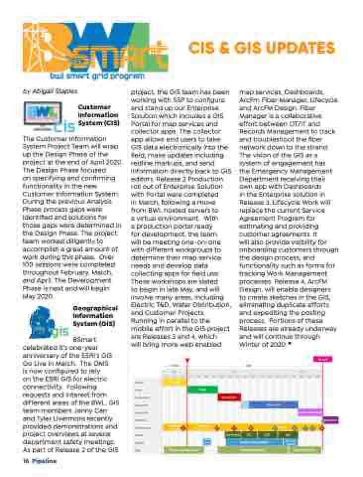
The Customer Information System Project Team will wrap up the Design Phase of the project at the end of April 2020. The Design Phase focused
on specifying and confirming functionality in the new Customer Information System. During the previous Analysis Phase process gaps were identified and solutions for those gaps were determined in the Design Phase. The project team worked diligently to accomplish a great amount of work during this phase. Over 100 sessions were completed throughout February, March, and April. The Development Phase is next and will begin May 2020.
Geographical Information System (GIS)
BSmart celebrated it’s one-year
anniversary of the ESRI’s GIS Go Live in March. The OMS
is now configured to rely
on the ESRI GIS for electric connectivity. Following requests and interest from different areas of the BWL, GIS team members Jenny Carr and Tyler Livermore recently provided demonstrations and project overviews at several department safety meetings. As part of Release 2 of the GIS
16 Pipeline
project, the GIS team has been working with SSP to configure and stand up our Enterprise Solution which includes a GIS Portal for map services and collector apps. The collector app allows end users to take GIS data electronically into the field, make updates including redline markups, and send information directly back to GIS editors. Release 2 Production roll out of Enterprise Solution with Portal were completed
in March, following a move
from BWL hosted servers to
a virtual environment. With
a production portal ready
for development, the team
will be meeting one-on-one
with different workgroups to
determine their map service
needs and develop data
collecting apps for field use.
These workshops are slated
to begin in late May, and will
involve many areas, including
Electric T&D, Water Distribution,
and Customer Projects.
Running in parallel to the
map services, Dashboards, ArcFm Fiber Manager, Lifecycle and ArcFM Design. Fiber Manager is a collaborative effort between OT/IT and Records Management to track and troubleshoot the fiber network down to the strand. The vision of the GIS as a system of engagement has
the Emergency Management Department receiving their own app with Dashboards
in the Enterprise solution in Release 3. Lifecycle Work will replace the current Service Agreement Program for estimating and providing customer agreements. It
will also provide visibility for onboarding customers through the design process, and functionality such as forms for tracking Work Management processes. Release 4, ArcFM Design, will enable designers to create sketches in the GIS, eliminating duplicate efforts and expediting the posting process. Portions of these Releases are already underway and will continue through Winter of 2020.
Go Live
mobile effort in the GIS project
Proposed Alternatives
are Releases 3 and 4, which
Scenario 1
will bring more web enabled
DSOW SOW
Oct
Analysis
Design
Development
Deployment
Shadow Run
Operations
Data Migration
D &
Testing
Training
OCM C
2021
Nov Dec Jan Feb Mar Apr May Jun Jul Aug Sep Oct Nov Dec Jan Feb Mar Apr May
2019 2020
Analysis
ata Scope Mapping 1
Design
ETL Design
& Transformation
Development
Deploy ment
Deployment
2
3 4
Unit Testing IST1 IST2
Develop Training Material Change Management
5
ETL Run
UAT
6 7 8
9
Parallel Testing Work
Operations
Core
Team Training
End User Training
Improve Proficiency
hange Impact Assessment
©Itineris - All Rights Reserved
4/13/20 1
