
Page 4 - 2016_ERDAS_IMAGINE_BROCHURE_HexGeo_Print_Neat
P. 4
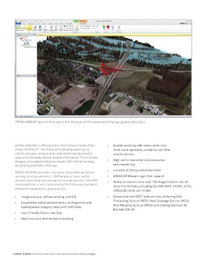
ERDAS IMAGINE was the first, and is still the best, at 3D visualization of all geospatial data types


          ERDAS IMAGINE is offered within the Producer Suite of the   •   Spatial modeling with raster, vector and
          Power Portfolio . The Producer Suite empowers you to       point cloud operators, as well as real-time
                       TM
          collect, process, analyze and understand raw geospatial    results preview
          data, and ultimately deliver usable information. This includes
          Hexagon Geospatial’s desktop-based GIS, remote sensing,   •   High-performance terrain preparation
          and photogrammetry offerings.                              and mosaicking
                                                                 •   A variety of change detection tools
          ERDAS IMAGINE provides true value, consolidating remote
          sensing, photogrammetry, LiDAR analysis, basic vector   •   ERDAS ER Mapper algorithm support
          analysis, and radar processing into a single product. We offer   •   Ability to convert more than 190 image formats into all
          many solutions in one, incorporating the following standards,   major file formats, including GeoTIFF, NITF, CADRG, JPEG,
          enterprise capabilities, and products:
                                                                     JPEG2000, ECW, and MrSID
                                                                                      ®
          •   Image analysis, remote sensing, and GIS            •   Comprehensive OGC  web services, including Web
                                                                     Processing Service (WPS), Web Coverage Service (WCS),
          •   Support for optical panchromatic, multispectral and
              hyperspectral imagery, radar, and LiDAR data           Web Mapping Service (WMS), and Catalog Services for
                                                                     the Web (CS-W)
          •   User-friendly ribbon interface
          •   Multi-core and distributed processing


        4 | ERDAS IMAGINE The world’s most widely-used remote sensing software package