
Page 884 - Divyank Tyagi
P. 884
850 | ChAPteR 21 Working With Point Clouds
than other reality data-capture technologies, but rather that you have the ability to collect
high-resolution, spatially accurate data about the entire environment of a site or building. It
really becomes about the ability to locate things accurately that were typically not located with
high accuracy in the past, like window and door openings, mechanical fixtures, and external
building detail. Again, it is not the overall accuracy that is valuable. Even if you did locate the
things like architectural detailing with a traditional survey, it was typically not spatially correct
to the rest of the building. Now imagine that you could have all of the internal and external
building openings located and shown together in the same model and then throw in the
architectural detailing and the building facades. That would be a very complete and accurate
picture of the existing conditions of a building, and that is exactly what you get with LiDAR.
There are two forms of accuracy when talking about LiDAR: relative and absolute. Relative
accuracy refers to the position of each x,y,z point in space and its location to all other x,y,z
points in that same space. Absolute accuracy is concerned with the real-world position of those
x,y,z points. It is important to be aware of the absolute accuracy of the point cloud if you are
trying to position something on a site that has to be specifically located. In most architectural
applications, relative accuracy is of more interest than absolute accuracy.
Imagine combining the clarity of a digital camera with the accuracy of a survey measurement
device. Actually, you don’t have to imagine this because this is essentially what a laser scanner
provides. When you combine these two things, you have a representation of the existing
world that will give you the ability to visualize things that have not been possible in the past.
Following is a series of illustrations demonstrating some of the common uses for LiDAR scans.
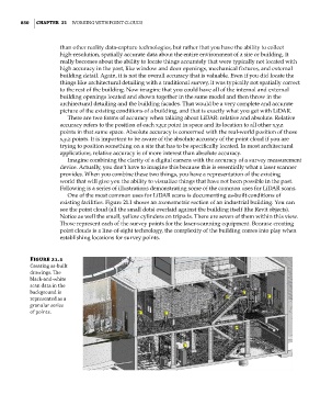
One of the most common uses for LiDAR scans is documenting as-built conditions of
existing facilities. Figure 21.1 shows an axonometric section of an industrial building. You can
see the point cloud (all the small dots) overlaid against the building itself (the Revit objects).
Notice as well the small, yellow cylinders on tripods. There are seven of them within this view.
Those represent each of the survey points for the laser-scanning equipment. Because creating
point clouds is a line-of-sight technology, the complexity of the building comes into play when
establishing locations for survey points.
Figure 21.1
Creating as-built
drawings. The
black-and-white
scan data in the
background is
represented as a
granular series
of points.
c21.indd 850 5/3/2014 12:05:41 PM