
Page 6 - Coastwatch_2024_v5b
P. 6
Coastal Geographic Research and
Applied Sciences Program
Advancing Regional Shoreline Management
through Innovative Data Interpretation
The Coastal Geographic Research and Applied Sciences Program
harnesses scientific data to tackle the challenges and threats
facing coastal communities as climate conditions rapidly change.
Recognizing that scientific information can be complex, the program
translates these data into clear, innovative tools and resources. By
doing so, it empowers municipalities, coastal managers, and the
public to interpret and apply this knowledge effectively at the local
level.
Launched in 2024, MapThatCapeCod.com is a public online
platform offering comprehensive shoreline management data
for the Outer Cape. The site provides interactive maps and visual
tools that present both contemporary and historical data, helping
users visualize and understand shoreline changes. It supports
coastal towns, local managers, and residents in
making informed, science-based decisions to
address erosion, sea level rise, and other climate-
related impacts, fostering effective and sustainable
management of the region’s coastal resources.
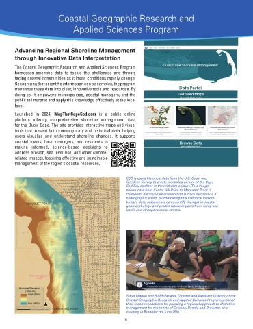
CCS is using historical data from the U.S. Coast and
Geodetic Survey to create a detailed picture of the Cape
Cod Bay seafloor in the mid-20th century. This image
shows data from Center Hill Point to Manomet Point in
Plymouth, displayed as an elevation surface overlaid on a
hydrographic sheet. By comparing this historical view to
today's data, researchers can quantify changes in coastal
geomorphology and predict future impacts from rising sea
levels and stronger coastal storms.
Steve Mague and SJ McFarland, Director and Assistant Director of the
Coastal Geographic Research and Applied Sciences Program, present
their recommendations for pursuing a regional approach to shoreline
management for the towns of Orleans, Dennis and Brewster, at a
meeting in Brewster on June 25th.
6