
Page 8 - Coastwatch_2024_v5b
P. 8
Shoreline and Seafloor Mapping Program
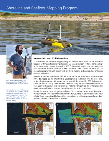
The JetYak mapping eelgrass
off Pamet Harbor, Truro.
Innovation and Collaboration
The Shoreline and Seafloor Mapping Program, now renamed to reflect its expanded
focus on both the seafloor and the shoreline, has been a vital part of the Center's geology
and ecology research since its launch in 2009. Collaboration is at its core, and partnering
with institutions like the University of Massachusetts CaPE Lab and the BEACON Lab
allows the program to work closely with graduate students and access state-of-the-art
mapping technology.
One of the standout tools in this initiative is the JetYak, an autonomous surface vessel
(ASV) developed by the Woods Hole Oceanographic Institution. This marine drone,
CCS Hydrographer Pedro dos equipped with advanced sidescan sonar, is currently being used by CCS Hydrographer
Santos operates the JetYak at
Pamet Harbor by remote control. Pedro dos Santos to map shallow water areas and study the loss of eelgrass habitats in
Cape Cod Bay. Supported by a grant from the National Park Service, the JetYak project is
providing critical insights into the health of these underwater ecosystems.
Previously, no recent information
on the bathymetry of the Pamet Locally, the program is working with the Town of Truro to study Pamet Harbor. In a recent
River was available (Left). The survey, the team collected detailed bathymetric data, building on earlier federal and state
seafloor has been mapped and efforts. These new data will help modelers accurately project how the Upper Pamet River
added to the existing data to
provide a full picture of Pamet system might evolve if tidal flow is restored.
Harbor. (Right)
8