
Page 9 - Coastwatch_2024_v5b
P. 9
Tracking Coastal Change from the Sky
The Shoreline and Seafloor Mapping Program is dedicated
to understanding Cape Cod’s evolving coastline. In
collaboration with the National Park Service, the program
identifies and monitors key erosion hotspots along the
Cape’s ocean side, known as “the backside.” These efforts
aim to link the erosion occurring onshore, at locations like
Nauset Light and Marconi Beach, with offshore processes.
The program’s approach integrates land and sea as
interconnected systems, using both drones and vessel-
based sonar to map these changes in detail.
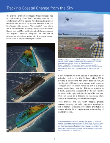
CCS Marine Researcher and FAA-certified drone pilot Dan Solazzo
flies the UMass Boston's Alta X drone, equipped with a coupled
hyperspectral and lidar sensor, at Thompson Island,
Boston Harbor. The hyperspectral sensor provides detailed
information on species present in the salt marsh, and their health,
while the lidar produces a high-resolution 3D map of the salt
marsh.
A key component of these studies is advanced drone
technology such as the Alta X drone, which CCS is
operating in collaboration with UMass Boston's BEACON
Lab. Recently, CCS researchers mapped a salt marsh on
Thompson Island in Boston Harbor as part of a project
funded by the Stone Living Lab. This survey provides an
in-depth, quantitative assessment of the salt marsh’s
vegetation and a high-resolution 3D map of its structure,
which will serve as a baseline for monitoring future
changes and developing conservation strategies.
These shoreline and salt marsh mapping projects
represent the program’s holistic approach, ensuring that
both terrestrial and marine environments are studied in
tandem, allowing for a comprehensive understanding of
coastal processes.
Surfaces and photomosiacs of Nauset Light Beach, an erosional
hotspot, created using drones and GPS data. These data and repeat
surveys allow monitoring of coastal erosion in three-dimensions
and helps the Cape Cod National Seashore better understand the
natural and cultural resources in the park as well as manage valu-
able infrastructure for park visitors.
9