
Page 33 - 74752_NSAA_LowRes
P. 33
US and around the world, Milliken says the A-Basin project has Squaw Valley, Stowe, The Remarkables in New Zealand, and
been a point of pride, as he first started skiing there in 1981. Sea Island, a seaside golf and beach resort mapped out over
“We were able to really zero in on what A-Basin wanted, 100 square miles along the Georgia coast. He’s also working
doing justice to both the front side of the mountain and the on a summer map for Killington. This new generation of
expansion areas—including the planned expansion and the maps provides for dramatically easier wayfinding, visual cues,
previous 400-acre Montezuma Bowl expansion they did on the informational overlays, and inter-active graphics that were not
backside in 2007—while putting the new terrain rollout into available with painted renderings.
a view and proportion to the rest of the mountain in time for “When I first went around promoting VistaMap as a new
their big announcement,” Milliken said. way of doing things for ski areas 20 years ago, I got a lot of
VistaMap specializes in vector-based digital map artwork pushback. Now the full potential of digital-based artwork and
for ski areas, amusement parks, zoos, museums, and other the technology to use it has caught up to the tools I’ve been
clients, but Milliken says ski trail maps are his bread and butter. using all these years,” Milliken said. Most people today have
“These are highly-detailed and complete maps that can that technology right in their pocket, so a user can open up a
be easily enlarged, reproduced, and quickly updated in digital map on their phone and see it clearly, potentially anywhere,
platforms,” he said. “It’s going to have the same clarity whether without the frustration of trying to fold a multi-paged paper
you’re looking at it on a folded trail map, on a huge sign map, or map in the wind on a lift.
zooming in on it with a computer or mobile device.”
While there will always be those who pine for the raphics technology is allowing ski areas to experiment
painted and artistically rendered mountainscapes of old, the even beyond digital map renderings. Cape Productions,
ease of use of digitally rendered maps and the visual clarity G for example, is moving its aerial drone videogra-
and accuracy they convey is here to stay. Milliken says that phy service away from its initial business model of offering
regardless of the size, he can print a map at 100 percent on-mountain use by guests on designated trails, like an aerial
without losing any detail, unlike with painted and hand- SharpShooter videography service. Now, Cape Productions is
drawn maps. beginning to use its expansive fleet of drones to offer guests a
“With a bitmap file, you either end up with an unman- “before you go” experience—in real time—by using drones to
ageably large file, or it starts to break up as you enlarge it,” he provide a video fly-over experience of a destination, right from
said. With VistaMap’s vector-based digital artwork, Milliken their home computer or Smart TV. Although in its early stages,
can create any file, in any size or format, so a resort can use the the company’s new business model is simply a taste of what is
raw file for print, make a web-optimized file for the internet or likely to come with this revolution in technology.
a mobile app, or whatever it needs—all in intricate detail and
precise navigability.
As the staff at Arapahoe Basin planned its expansion
announcement, Milliken was able to create a map to better
visualize what the terrain would look like once opened, while
still being able to fine-tune it in the future once the chairlift
and new trails are in place.
“Making them easy to update is a big part of the value in
my maps and the service that I offer, well beyond the initial
creation of a map,” Milliken said. “I’ve always described it as
a painting where the paint doesn’t dry: I can go in and select
any object in the map, down to an individual tree, to make
changes at any time if at some point a ski area makes a change
and wants it reflected on the map. If your original trail map is
an actual painting, as is often the case in this industry, that can
be a lot harder to do.” Gary Milliken/VistaMap
Milliken says it took a while for technology to catch up
with the capabilities of his maps. But smartphone applica-
tions like Vail Resorts’ EpicMix—which feature VistaMap
for Vail Mountain and the company’s other resorts—hint
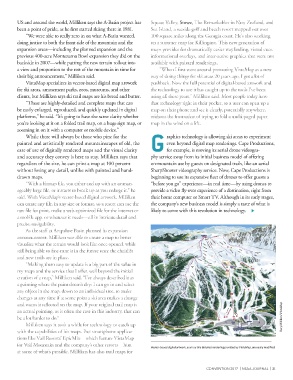
Vector-based digital artwork, such as this detailed rendering provided by VistaMap, are easily modified.
at some of what’s possible. Milliken has also trail maps for
CONVENTION 2017 | NSAA JOURNAL | 31